![]()
|
Index
•
|
|
Welcome
•
|
|
21st Century•
The Future |
|
World
Travel•
Destinations |
|
Reviews•
Books & Film |
|
Dreamscapes•
Original Fiction |
|
Opinion
& Lifestyle •
Politics & Living |
|
Film
Space •
Movies in depth |
|
Kid's
Books •
Reviews & stories |
|
|
|
|
The International Writers Magazine: USA Travel
Cumberland Gap
• Ari Kaufman
After two lovely dinners in the Cincinnati (OH) suburbs with family friends, my fiancée and I left the highlands of southwestern Ohio for a two-day road trip into Scenic Kentucky, another under-rated American state in terms of beauty and history.
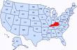
We crossed the Ohio River on a bleak day in the low 40s, then hurdled south on Interstate 75 toward the southeastern part of the Commonwealth, arguably its most agreeable portion. About two dozen miles before the Tennessee state line, we turned onto old US Highway 25 and made a 40-mile southeastern beeline for the incredible Cumberland Gap National Historic Park.
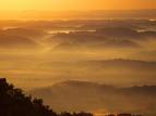
When Maria and I parked and walked about 200 yards to the zenith, all the day's driving was well worth our time. Gorgeous, diverse views of three American states at sunset quickly presented themselves.
As is often the case in this part of the country, the sun made about a 90 minute appearance at the end of the day, which was perfect and welcome as Maria and I made a four mile twisty traipse up to an area of the Park called "Pinnacle Overlook." As we rose in a steep, circular pattern around the base of the mountain, snow and deer could be spotted as the elevation increased dramatically from roughly 1600 feet to just under 3000 feet.
First was Middlesboro, Kentucky, a town of just under 13,000 folks to the northwest; then Historic Cumberland Gap, Tennessee, was dead center, directly below us, nestled in charming hills, some 2,000 feet below. The Cumberland River snaking its way southwest through undulating autumnal hills toward Nashville and Central Tennessee was beyond that---with the Smokey Mountains off to the due south about 80 or so miles. Third and lastly, about eight steps to our left was a view of the extreme southwest corner of Virginia and Powell's Valley with the southern terminus of the Blue Ridge Mountains far in the distance.
Remember, Virginia's northern edge is just across the Potomac River from Washington DC, but this might as well have been another world, as we clearly sat in the Midwest or southern portion of the US, depending upon whom you ask. In fact, Maria and I were standing more than 500 miles from Virginia Beach and any oceanfront land in the Commonwealth. We also were a poke under 460 miles from the Nation's Capital. Virginia is an enormous state with an equally enormous history. And to think that for more than 250 of its 400 year existence (since the settlement of Jamestown), present-day West Virginia, another of America's treasures, was part of the same state. Well, it's enough to never make you step foot in centers of debauchery and vapidity like Los Angeles, Las Vegas or Miami ever again.
Truly then, the Cumberland Gap was as good as anything I have seen in my 48 states of American travels, especially with the sudden snow at 3000 ft and the history:
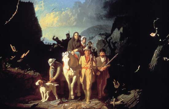
Three hundreds thousand settlers crossed this brutal and narrow gap---the chief passageway in the "middle" of the immense Appalachians---between 1775-1810 on their way to Kentucky, as well as the lands of the Midwest and Ohio Valley. Daniel Boone had led a company of men to widen the path through the gap to make settlement of Kentucky and Tennessee easier in 1775. The trail was again widened in the 1790s to accommodate wagon traffic. Today 18,000 cars pass beneath the site daily via the Tunnel built in 1996, and 1.2 million people visit the park annually.
From the National Parks Site:
Cumberland Gap is a prominent V-shaped indentation in the Cumberland Mountains. It is situated on the Kentucky-Virginia boundary approximately one-quarter mile north of the point where Kentucky, Virginia, and Tennessee meet. The base of the pass lies in a plane 300 feet above the valley floor and 900 feet below the pinnacle on its north side. On the south side, the mountain is only 600 feet above the saddle of the Cap. Viewed from a distance, this picturesque natural feature probably appears much the same as it did when seen by the first pioneers. However, a closer look will reveal that the north side of the pass has been sliced by a modern highway to a depth of approximately twenty feet.
Or, as wikipedia notes:
The gap was formed by an ancient creek, flowing southward, which cut through the land being pushed up to form the mountains. As the land rose even more, the creek reversed direction flowing into the Cumberland River to the north. The gap was used by Native Americans and migrating animal herds.
Like many parts of the American colonies and current eastern and Midwestern towns, The Gap was named for Prince William Augustus, Duke of Cumberland. The explorer Thomas Walker, who has a historic site in the Park and throughout the region, also gave the name to the Cumberland River in 1750, and the name soon spread to many other features in the region, such as the Cumberland Gap.
As the sun descended, we took a cursory visit to the Historic town of Cumberland Gap, Tennessee on the other side of the pristine tunnel, and were off for dinner and a 45 mile ride back on the state highway to our hotel in Corbin, near Interstate 75, whereupon tomorrow's journey would commence.
On the way, one of many snapshots of American presented itself near the town of Pineville, where cars lined the highway for literally the better part of two miles to enjoy a high school football game, likely a county title tilt. Pure Americana on a dark, cold evening. Also, New Deal Era Public Works Projects were abundantly evident from their time during FDR's term in the 1930s Great Depression Era. Of course, this area was the heart of the Civilian Conservation Corps and the Tennessee Valley Authority, which was headquartered in Knoxville (TN), just 60 miles southwest of where we were.
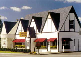
In 1939, fire destroyed the original eatery, which Sanders then quickly rebuilt as both a restaurant and motel. For many years, the restaurant and motel served as a popular stop for travelers driving along what was then the major north-south route — US 25. Business continued to boom until the completion of Interstate 75.
Crisp, bright air greeted us Saturday morning as we matriculated two miles down the road for a touristy, yet historic, stop. The original "Colonel Sanders Cafe," which is better known today as Kentucky Fried Chicken, is still standing in Corbin. Well, essentially it is.
Some brief history shows that Harlin Sanders, who was born on Sept. 9, 1890 in Henryville, Indiana, lost his father at the age of six. After completing the sixth grade, Sanders quit school and went to work at a variety of jobs. However, it wasn’t until 1930 that Sanders moved to Corbin, where he would one day forge the culinary empire for which he was famous.
Once in Corbin, Sanders opened this service station, where he operated a lunchroom that consisted of one table, surrounded by six chairs. Business expanded quickly, and by 1937, Sanders had built "Sanders' Cafe," which seated 142 customers. At this restaurant, it was soon discovered that Sanders' fried chicken was the most popular selection on the menu.
In the late 30s, Sanders was commissioned as a Kentucky Colonel by the state's Governor, and was re-commissioned in 1950. Although he had been a Kentucky Colonel for nearly two decades, it wasn’t until after 1950 that Sanders began to look the part we know today, growing his trademark goatee and donning his white suit and string tie.
In 1964, Sanders sold his franchise business to former Kentucky Governor John Y. Brown Jr. and Jack Massey for $2 million. Sanders was, of course, retained on salary as spokesman for KFC.
A benevolent and pious fellow who reportedly contributed money to religious charities, hospitals, medical research, education, the Boy Scouts, the March of Dimes and many others, Colonels Harlin Sanders died on Dec. 16, 1980. His body then lay in the Kentucky State Capitol Rotunda in Frankfort before burial in Louisville’s famous Cave Hill Cemetery where more than 120,000 others ultimately rest. Included in that figure are more than 200 Confederate Soldiers, Revolutionary War Hero George Rogers Clark, governors, congressmen and 28 former Louisville mayors.
The game has been played each year for more than a century, with the Volunteers of Tennessee holding a sizable advantage, unlike in basketball where Kentucky has won 139 of the 203 meetings. (I later learned, via a cell phone call from my father, than Kentucky, who was having one of their rare good years in football, almost beat UT, but Tennessee won 52-50 in four heartstopping overtimes, for their 23rd consecutive win in the football series. Brutal.)
And then we motored north through the clouds until we hit Kentucky's largest city by population, Lexington, around 1pm. The town seemed half-dead, which caused me to ponder and quickly realize that today was the HUGE Kentucky-Tennessee football game. I should have know this since Middlesboro and Corbin essentially sit on the Dividing Line for Lexington and Knoxville, TN.
So with Lexington quaint but desolate, our Nissan headed west about 78 miles to Kentucky's largest city in terms of sheer size and metro population, Louisville.
The ride in between, which I had done back in December 2004 on a cross-country sojourn, is wonderful. For most of it, verdant horse farms with white picket fences stretching for hundreds of yards alongside the Interstate, surround you. The hallmark of the drive, as I see it, comes as you approach the fantastic town (and Capital City of the Commonwealth) of Frankfort along the Kentucky River. For about two miles as you approach the river that criss-crosses Frankfort a few miles north of I-64, limestone cut outs from blasts of half-a-century ago, engulf you. Then you are swooped briskly downhill until you cross the monstrous river. Following this, the road pushes you up again, past more limestone, before leveling off back into the low hills and farms on your way to "Loo'ville." It's a rush. I don't expect those who enjoy Yoga in Boca or shopping in Santa Monica to understand at all. Shame.
Frankfort, Louisville and Southern Indiana, which we ended our trip enjoying as the day and holiday weekend ended, are discussed in my past articles. But overall, this chilly and somewhat rushed adventure was well worth the experience.
Frenchlick.htm (L-ville and S. Indiana)
Ari10.htm (Frankfort and KY)
© Ari Kaufman December 2007
www.ajkauf.com
More World Journeys
Home© Hackwriters 1999-2008
all rights reserved - all comments are the writers' own responsibiltiy - no liability accepted by hackwriters.com or affiliates.