![]()
|
Index
•
|
|
Welcome
•
|
|
21st Century•
The Future |
|
World
Travel•
Destinations |
|
Reviews•
Books & Film |
|
Dreamscapes•
Original Fiction |
|
Opinion
& Lifestyle •
Politics & Living |
|
Film
Space •
Movies in depth |
|
Kid's
Books •
Reviews & stories |
|
|
|
|
The International Writers Magazine: USA Travel
800 Miles
• Ari Kaufman
Eight hundred miles of driving in a single weekend--much of it on the windy, back roads of Indiana, Kentucky and Tennessee? Sound boring, dull, tiring? I could not disagree more, which is why Maria and I embarked upon such a journey on a sunny March weekend with spring finally showing itself, even if briefly.
Image Parthenon: Nashville
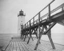
After our usual 15 minute stop in the architecturally-stimulating town of Columbus, Indiana, to see the Bartholomew County Courthouse, Driftwood River, lovely main street and their vertically-impressive War Memorial, we continued south on Interstate 65 passing towns like Seymour, Scottsburg and eventually Hanover, before diverting east and down the steep hills to the rivertown of Madison, Indiana, approximately 50 miles northeast of Louisville, Kentucky.
On the warmest Indiana day since November, we walked along the Ohio River, gazed at the antique stores on downtown's Main Street, and even found a random basketball court along the riverwalk at the corner of Vaughn St. and Broadway. We also walked by and gawked at the salmon-colored Lanier Mansion, the former home of pioneering businessman James Franklin Doughty Lanier. What is the history there? According to their website, "visitors will learn more about Lanier's life as well as life in general during the 1800s." They do give tours so there much be more than that, but we had to move along.
As early as 1806, people began settling there, and the town officially incorporated in 1824. In Madison's early years, it was naturally bustling with heavy river traffic and its position as an entry point into the Indiana Territory along the historic Old Michigan Road.
At 12,000 people, Madison is not a large town, but has, as many port cities do, an impressive history. Hence, in 2006, the majority of Madison's downtown area was designated one of the largest national historic landmarks in the United States.
Indiana's first railroad, the Madison-Indianapolis Railroad, was built there between 1836 and 1847. However, when river traffic declined and new railroads were built between Louisville, Indianapolis, and Cincinnati Madison's trade network had been tapped into. As a result, as was often the case with Midwestern river cities near the turn of the 20th century, Madison went into an economic and growth decline. Today though, the town's misfortune leaves for a preserved collection of early 19th century architecture in the "Federal and Greek Revival styles," many of which are still currently being "revived" and restored.
Half-an-hour of baksetball and walking exercise later, we turned up Broadway and drove through town one last time before turning onto Highway 421 South and crossing the Ohio into the Kentucky town of Milton. Before we could see Milton--and it's firework sales--we were sent up a twisty incline and into the hills only to get one passing glance at the town of Madison which gave us an "aerial" understanding of what a river settlement looks like, and why it was so vital to America's progress and expansion nearly 200 years ago.
The next 90 minutes presented some of the windiest terrain I had seen, and considering my extensive travels the past few years, that's saying something, especially in Northern Kentucky. At times, the scenery was pleasant--with clear skies and the Little Kentucky Creek at our side most of the time. But the small towns were not even close to as serene and pleasant as those in my Hoosier State (few, sans Vermont, Mississippi and Virginia are) and I had to keep my eyes on the road until we finally descended (big time) into the Kentucky State Capital of Frankfort around 3pm.
This being my second visit to Frankfort in the past 26 months, I re-confirmed my view that this town of just 27,000 people is one of America's best-kept secrets.
After a nice lunch in a pleasant and clean tavern on, yep, Main Street, we took a lovely walk in the mid 60s temps around a strangely empty town. Locals and those who have visited often compare downtown Frankfort to something out of a 1950s movie set. I couldn't agree more. Those were the days.
As time went by, people began filing into town for Saturday night activities, and we walked past the bookstores, coffee shops, statues and the old Kentucky State Capitol building where many photographers had gathered to take shots.
First surveyed by a Virginia lawyer in 1777, Frankfort became a full-fledged city 15 years later, the same year Kentucky was admitted to the Union.
Frankfort's early history is fascinating yet complex. This taken from the history of the city:
The Kentucky General Assembly appropriated funds to provide a house to accommodate the governor in 1796. Construction was completed in 1798. The Old Governor's Mansion is reputed to be the oldest official executive residence still in use in the United States. In 1829 the Old Capitol, the third Capitol of Kentucky was built in the Greek Revival style by Gideon Shryock. The building served the Commonwealth as its Capitol from 1830 until 1910.
During the American Civil War fortifications overlooking downtown Frankfort were built on what is now called Fort Hill. The Confederate Army occupied Frankfort for a short time. On February 3, 1900, Governor-elect William Goebel was assassinated in Frankfort while walking to the capitol to be inaugurated. Former-Secretary of State Caleb Powers was later found guilty in a conspiracy to kill Goebel.
Thus today, and for nearly a century, the capitol building of the Commonwealth of Kentucky, sits on a massive plot of land just outside town with the Governor's Mansion and many ancillary buildings around it. It's a beautiful drive up to the structure as you cross a few rickety old antebellum bridges over the Kentucky and Elkhorn River which separate various parts of Frankfort, then go straight up a smooth two-lane hill with grass in the middle until you hit about 300 yards of stairs and grass; then there's the enormous building. It's quite imposing for such a small city. For comparison, my hometown of Indianapolis is roughly 50 times the size of Frankfort, yet our capitol building--and surely the area around it--is not half as large.
On our way out of town, we stopped at s scenic overlook to watch the sun dip behind the golden dome of the capitol, with white-walled New England-style houses in front and the hills of Kentucky in the backdrop. It's not hard to understand why the city, even in a rusty part of the mid-south, has seen considerable growth since the 1960s.
After this, we drove 65 miles west on one of the Kentucky parkways--The "Martha Layen Collins," I believe; but this east/west road changes names three or four times throughout the state, so I'm only modesty certain. The parkway was rather pleasant since no 18 wheelers are allowed.
At Elizabethtown, just past the "Lincoln Region" ("Dry" Lincoln County, Lincoln Homestead/Heritage State Park, Boyhood Home, Birthplace National Historic Site--we've got some of those in Indiana too, of course) and Bardstown (home of the Oscar Getz Museum of Whiskey) we rejoined I-65, then hurdled about 100 miles south, crossing into Tennessee, and finally cruising the last 35 miles south to our hotel in Nashville where we spent the evening.
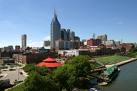
NashvilleNashville, Tennessee, is a great town. I have never heard any visitor say differently. We spent a few minutes on the outskirts of downtown at a blues club called The Station Inn, before matriculating back to downtown and fighting the post hockey game traffic (yes, hockey in the Volunteer State) until we located a parking space.
On this unseasonably warm (and welcome) weekend, people were walking around "Music City" in their short sleeves. It was pleasant, as we listening to the famous country music emanating from the bars, clubs and restaurants on 2nd Avenue North. Finally, after the club scenes eventually made life a bit too loud, young, annoying and obnoxious for us "old folks," we found the famous Demos Steak and Spaghetti House for a nice meal around 10pm.
Sunday morning was, not surprisingly, quieter on the banks of the Cumberland River in Tennessee's capital city. Though some people were out, the sun shined magnificently over a peaceful downtown, as we circled through some of the areas we had visited ten hours prior. Then we drove a few miles down West End Avenue to the campus of Vanderbilt University, where to my pleasure, players were warming up for a 1pm baseball game. Quite a site. We meandered through the gates and manicured lawns of the private college before departing north on the interstate back toward the Kentucky border. {As an aside, Nashville has over 15 four year colleges, with many being religiously-affiliated and just one (Tennessee State University) being public.}
We rode rapidly up the beautiful and sunny interstate, which at this point is shockingly prettier than the parallel state highway (31), a true rarity in America. Passing the city of Bowling Green and the National Corvette Museum, we exited 48 miles into Kentucky in Park City, headed northeast into Mammoth Caves National Park.
Kentucky Highway 255 was a melancholy road that led into the National Park with equally pristine pavement that we drove seven more miles past ponds, barren trees and even three deer until we hit the Visitor's Center. With our time somewhat limited, we eschewed the $12 cave tours--that were mobbed with fat tourists--for a two mile hike in the woods on one of the many walking trails. It was a brilliant decision.
The traipse took over an hour, and though hilly, was not overly strenuous. We hiked along the bluffs and cliffs that hung over the Green River (yes, it really was green thanks to the water's depth) on this sun-soaked day. The windy river was finally viewable from a breathtaking lookout about three-quarters of the way into the hike. At that point, it snaked away toward the northwest in an undulating fashion that would make a signature golf hole envious. And this river, upon reading the informational sign, had history. That's nothing new in the Midwest, where the history is as deep as the people are amicable.
A tributary of the Ohio River to its north, the Green River was used as a transport canal after various locks were created. Though it has nothing on the historic and massive Soo Locks in Sault Saint Marie, Michigan, the Green River was significant and important to midwest transportation. But In 1941, Mammoth Cave National Park was established, and the two upper locks and dams closed in 1950. In 1965, Lock and Dam #4 at Woodbury, Kentucky failed. Eventually, in 1969, the United States Army Corps of Engineers impounded the river, forming 8,200-acre Green River Lake. The lake is now the primary feature of Green River Lake State Park which sits inside the National Park.
According to Wikipedia:
The Green River flows through Mammoth Cave National Park and drains the cave and controls the master base level of the Mammoth Cave System: the construction of a 9 foot (2.7 m) dam at Brownsville, Kentucky in 1906 has raised the water level in some parts of the cave system by as much as six feet (1.8 m) above its natural value.
The 300-mile long Green River, an important transportation artery for the coal industry, is open to traffic up to the closed Lock and Dam #3 at mile 108.5. Muhlenberg County, once the largest coal-producing county in the nation, benefits greatly from access to the river, as does the aluminum industry in Henderson County.
Several of Kentucky's record fish have been caught in the Green River including a 97 pound catfish in 1956. I'd comment more on 66 year-old Mammoth Caves NP but since I did not go into the caves, I reserved my comments for the outdoor portions we enjoyed on a wonderful Sunday in early March.
On the first day of Daylight Savings Time – in a year where we "sprung forward" earlier than ever--we exited the park at 4pm with much light still in the air. After a brief stop to look at the unique and quaint town of Elizabethtown (site of a movie I never saw), we cruised up toward Louisville, 45 miles north at this point.
Driving through "Looville" around 5pm, the city looked very pretty. Crossing the Ohio River was thrilling as always, as we exited immediately--at Exit 0--to eat an early dinner along the river's banks in Clarksville, Indiana, at Falls of the Ohio State Park, enjoying a postcard-quality view of the Skyline of the Northernmost Southern City/Southernmost Northern City. {For more on Louisville, see my prior travel article from January.}
For the final hour as the sun slightly dipped, Maria napped and I enjoyed the radio broadcast of the NCAA Basketball Tournament Selection Show and my phone call debates with friends that immediately followed.
We stopped for a 7:15pm viewing of Charlotte's Web at the old-fashioned Columbus (IN) movie theatre about 40 miles short of Indianapolis. It was a minor, and enjoyable, concession from me to Maria after she accommodated and tolerated me on such a whirlwind, but lovely weekend sojourn.
© Ari Kaufman March 2007
ajkauf7@yahoo.com
Hoosiers in the Fall
Ari Kaufman
Lakes, hiking, camping
Indiana and Appalacia
Ari Kaufman on the road
The Road to Thanksgiving
Ari Kaufman drives 1000 miles for dinner
Not Sleeping Just Waiting
Ronan Dockery
Christmas Eve in Recife with only a slight hangover ...
Ozark Adventure
Ari Kaufman
My fiancee and I (well, maybe just me) felt it incumbent upon us to embark on one final road trip to what many call “the American heartland.
Where North Meets South
Ari Kaufman
"Looville" is Kentucky's largest city. Founded in 1778 it is best known as the home of "The Most Exciting Two Minutes in Sports"
Driving America
Ari Kaufman - Fingerlakes
February - a good time to remember the summer in America's Mid-West
More Destinations
Home© Hackwriters 1999-2007
all rights reserved - all comments are the writers' own responsibiltiy - no liability accepted by hackwriters.com or affiliates.