![]()
Welcome • |
About
Us • |
"You'll be taking one of the world's most breathtaking train journeys", Miguel my Mexican guide in Acapulco, appeared to be starry-eyed after I told him that I was flying the next morning to Chihuahua to travel through the Copper Canyon (Barranca del Cobre), also known as Sierra del Tarahumara after the local Indian tribe who inhabits the area. He continued, "It's one of the wonders of the world. Its grandeur and beauty will take your breath away." He sighed, "You're lucky. I wish I was going with you."
Photo © H SalloumThat night, I thought of Miguel's words, hardly sleeping a wink, so great was my excitement. Before travelling to Acapulco, Mexico's renowned seaside tourist resort, I had read much about what travellers have characterized as one of the Western Hemisphere's great scenic and spectacular canyons. Even before Miguel had described it in glowing terms, I knew that a traveller through that canyon would cross some of the world's most awesome landscape, carved over millions of years by the natural elements. The next morning my excitement mounted by the minute as I waited for the plane to take us to Chihuahua - the capital of the sparsely populated state of Chihuahua. With an area of 247,000 sq km ( sq mi), it has only 2 million inhabitants, but it is the largest state in the country, consisting of rich farmlands, arid deserts, grasslands, deep canyons and steep-rugged mountains.
A few hours later, while still thinking of its canyons and mountains our plane landed in Chihuahua - a sprawling city of 1 million located on a high plain, noted for its zero unemployment and as the home of Miguel Hidalgo, father of Mexican independence, and General Pancho Villa whose armies in 1910 overthrew the dictator Porfirio Díaz. It was to be the starting point of our journey through one of Mexico's most noted mountain attractions which draws hard core packers, mountain bikers, hikers, naturalists and even senior citizens. Most travellers, in order to relish this picturesque countryside, take the 673 km (417 mi) train trip which runs between Chihuahua and Los Mochis on the Pacific coast. One of the most scenic train rides on earth, it is a journey through an extraordinary and wondrous landscape.
Built over a 90 year period, the Chihuahua- Pacifico Railway, known as El Chepe, traverses through one of the most rugged areas in Mexico. It was completed after extraordinary efforts in 1961 and is considered to be one of the great feats of the 20th century. Portrayed as an engineering marvel, it passes through 86 tunnels and over 222 bridges - one almost a mile above the canyon floor.
The train functions as a cargo corridor connecting Mexico's northern interior with the Pacific coast. However, in the last decade tourism has taken on an increased importance and the train ride is now advertized by Chihuahua Tourism as an exciting journey through one of the natural wonders in the world.
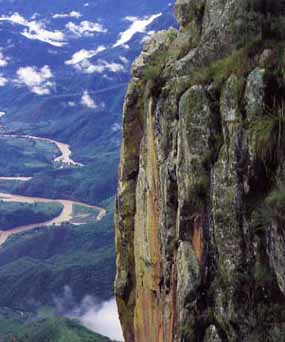
Well do the tourist officials have a point. The train passes through the wild and rugged Sierra Tarahumara, a part of the Sierra Madre Occidental, with peaks reaching 2440 m (8,000 ft). An enormous geological complex carved by seismic volcanic activity, rivers and wind erosion over eons, the Sierra Tarahumara encompasses an impenetrable maze of 200 gorges which combine to form a series of six massive interlocking canyons, known as the 'Copper Canyon'. Combined, they total 1452 km (900 mi) in length and are North America's largest canyon systems - four times larger than the Grand Canyon. Some, from their snow-covered peaks to their semitropical canyon floors, are deeper than the Grand Canyon by some 305 m (1,000 ft).
An impossible barrier, it is still un-breached in many places by road or even trail. Only a few Tarahumara Indians who live in the Canyon's depth and still fewer miners are familiar with its few uncharted footpaths. Much of the canyon system is still beyond the cutting edge of civilization. Our intention was to ride El Chepe, but only after we had toured a part of the route by bus. We were told that this would give us time to stop at interesting places and, hence, make the trip more rewarding. Leaving Chihuahua behind, we drove through a rich agricultural-scenic countryside. In the heart of this well-tended farmland, we stopped in the town of Cuauhtemoc - a trading centre of 200,000 for a series of Mennonite settlements, or as they are locally called, camps. These camps, which occupy a 100,000 ha (247,000 ac) area, were established in 1922 by some 2,000 Mennonites, a hard-working Germanic Protestant sect, who were fleeing from government regulations in Canada and the U.S.A. Today, over 50,000 descendants of these early settlers still speak Low German, the language of their ancestors, but have adapted well to most aspects of the Mexican culture. They have made the region the most productive area in the whole of Mexico - noted for its apple, peach and pear orchards; bean, corn, potato and grain production; but, above all, for its white cheddar-style cheese, found all over Mexico. We stopped at one of the many small cheese factories run by one of the Mennonite families. The young lady managing the attached store, selling homemade breads, cakes, sausages, and the famous home-made cheese, was efficient with her customers, almost all Mexicans - a good number coming from distant places. Mennonite cheddar-cheese is much sought after throughout the country and, along with the other agricultural products produced in the camps, have made this Germanic sect beloved to many Mexicans.
From Cuauhtemoc we drove through well-tended apple and peach orchards, then drove across juniper and oak-covered hills, in places dotted with corn fields and scattered apple groves. At La Junta, we turned southward and were soon driving through rolling hills covered with coniferous forests which continually thickened as we climbed upwards. At the 2,440 m (8,000 ft) level, we stopped in San Juanito, a lumber town, defusing the aroma of wood-resin everywhere. The coldest town in Mexico, it reminded me of a Canadian or U.S. mountain lumber town. A short time later, as we approached Creel, a rugged lumber, mining and ranching centre, a lady sitting next to me remarked, "Look! It's the wild west!" I glanced below me. The town located in a high valley and surrounded by mountain peaks looked like it could very well have come out of a western movie.
A scrambled collection of rustic homes and artisan shops, Creel, considered to be the gateway to the Copper Canyon, is the largest urban centre in the Sierra Tarahumara. Located 335 km (200 mi) from Chihuahua at an elevation of 2,312 m (7,708 ft), it is a frontier village of some 6,000 with a somewhat rough reputation.
The starting point for all activity in the region, it has some 20 hotels, numerous restaurants and many shops. Its popularity as a tourist stop is constantly growing. Hotels and tour operators offer escorted trips and treks around the area and backpackers and hikers begin from here to explore the surrounding countryside with its Alpine forests, hot springs, lakes, waterfalls and native cave hamlets. After exploring the city we left for a tour of the countryside, during which we visited the tree-encompassed Lake Arareko, the Jesuit mission of San Ignacio and the Valle de los Hongos, noted for its bizarre balancing rock formations. However, the highlight of this tour was a stop at one of the Tarahumara cave homes. It was a journey into the distant past - the time when most people in the world lived in the primitive fashion as do the Tarahumara today.
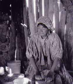
Tarahuma Women © H Salloum
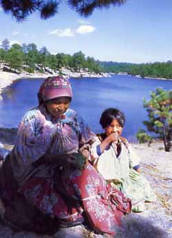
Creel is the heart of the Tarahumara Indian territory. Its shops overflow with their artisan products. Here, from necklaces to woven belts, one finds the best of their handiwork. The streets are filled with colourfully dressed Indian women and young girls offering their handicrafts for sale. Shy and humble, the older women never push their products on visitors. The Tarahumara or Raramuri (foot runners) as they call themselves, are probably the most isolated and nomadic- indigenous peoples in North America, living in the same primitive way as had their legendary ancestors.
Retreating deep into the back country to escape Spanish enslavement, missionary indoctrination and later settlers, they have been able to preserve much of their culture. Scattered over 25,900 sq km (10,000 sq mi) of mountains and canyons, the 50 to 70 thousand Tarahumaras, noted for their running abilities and endurance, are the most authentic Indian group in the Americas. To outsiders, they are somewhat invisible and cannot be seen unless they so desire. Living close together in four to five family units, it is almost impossible to tell their number and location. Nevertheless, they are everywhere in this region of Mexico.
Extremely shy, most Tarahumaras, with the exception of those working in towns, have little contact with visitors. Eking out a living from simple subsistence farming, they live in caves or huts in the inhospitable canyon system: high on the cliffs sides in summer; and lower down near the canyon floors in winter.
However, some reside in towns and have become skilful workers, employed in construction. They learn quickly to operate heavy machinery and other equipment. The government has built for them boarding schools where they are taught, besides Spanish, their own language. Many are today quickly joining the Mexican mainstream but, at the same time, more than any other indigenous group, they are proud of their history, retaining their language and culture, especially their folklore. In the afternoon that day, we drove to the Copper Canyon Sierra Lodge, a rustic cabin-style lodge located on the edge of a stream, running between pine-covered mountains - an ideal atmosphere for hikers and nature lovers. From this pastoral abode in the wilderness, we began our walk along the river bank toward the 30 m (98 ft) high Cusarare Waterfall - some 4 km (2.5 mi) away. About half way, some of the older members of our group turned back; the others reached the falls, then returned tired but content. As we sat by a fireplace, much needed due to the lodge's elevation, enjoying tea and cookies, an American girl from Boston working as a guide beamed, "Do you like our beautiful and clean-fresh world? It's unspoiled nature at its best." Early the next morning we drove 44 km (27 mi) through rugged forested mountains to Divisadero del Barranca, located on the Continental Divide. Here, half way between Chihuahua and Los Mochis, the El Chepe stops for 15 minutes at a breathtaking lookout where passengers can enjoy a spectacular view of the three canyons below.
The amazing sweeping vistas of the jungle canyons with their yawning chasms and plunging rock walls create a world of make- believe. In the clear and crisp mountain air flowing through the unbroken ocean of pine forests we gloried in the best of what mother nature had to offer. We could see for, perhaps, 100 km (61 mi) the wondrous view of where the Urique, Copper and Tararecua Canyons meet - for travellers on El Chepe this sight is the highlight of their train journey. Walking along the rim of the Urique Canyon some 2,370 m (7,800 ft) above sea level, I could not get enough of the grandeur below. The shining citadels of rock bathed in coppery-green iridescence and reaching up to a clear blue sky made for a scene of engrossing splendour. The only distraction were groups of people making their way down to the Urique Canyon's floor, some eight hour trek down and 12 hours back, with usually a camping stop overnight. The whole aura for me was a rivetting tableau, too beautiful to leave - a scene from the land of fantasy. From this gripping site, we made our way to the train station where we planned to take El Chepe to Los Mochis, hoping to enjoy to the utmost the other scenes which the Sierra Tarahumara had to offer. The station, one of the region's most popular stopovers, was a melee of activity. Food and handicraft vendors were everywhere. It was a shopper's delight, giving us a chance to buy Tarahumara handicrafts and a brief glimpse of Tarahumara women weaving baskets, indifferent to the clamour around them. The calmness of these working women contrasted vividly with the chatter of the passengers waiting to board.
The panorama seen from the left side of the train is much more eye-catching than the view on the right. Soon we had choo-chooed past Guiteco, set in the middle of apple orchards. Thereafter, the train began its precipitous drop to sea level as it careened along the rim of a canyon. Now the air became warmer and, as we moved forward, the vegetation gradually became tropical. At the lumbering town of Bahuichivo, a group of tourists got off to visit Cerocahui, a historic-picturesque town. Nearby, one can witness from the Gallegos Lookout one of the most beautiful sights in the Sierra, the Urique Gorge, town and river.
Onward we traversed a spectacular landscape. On and on the train wound its way into the canyon regions, passing through an endless array of tunnels and trestle bridges. It was a breathtaking ride, made charming by cascading waterfalls and colourful wild flowers intermixed with a blanket of shrubs and trees, growing out of a landscape of huge rock walls, soaring above the canyons. All these spectacular sights of an awe-inspiring terrain we enjoyed from our vantage point while seated in a comfortable train. The 40 km (24 mi) stretch between Bahuichivo and Témoris when the line plunges 610 m (2,000 ft), threading through 16 tunnels, was vividly described by Joe Cummings when he wrote in his Northern Mexico Handbook: "Looking over the scene from one of the rail cars is like finding yourself miniaturized and magically transported into an elaborate toy train set-up."
After stopping awhile in Témoris, overshadowed by towering cones of rocks, we passed through a 1819 m (5,966 ft) long tunnel - the longest we traversed during the trip. Westward from Témoris, we continued the downward descent, crossing the Río Chímpas and Río Septentrión. From the Loreto Station, we travelled through a relatively uninhabited jungle-like countryside. Continuing past El Fuerte, called the 'gateway to Copper Canyon', we moved through the state of Sinaloa until we reached Los Mochis, a modern and prosperous agricultural city of 400,000 with a good tourist infrastructure, but with a mundane aura - an anticlimax to an awe-inspiring journey. The pride of the Mexican rail system, our choo-choo had taken us through a maze of misty, pine-clad mountains whose faces fall down to roaring rivers, meandering through the canyon depths below. Amid these marvels of nature, it is said, the ghost of Pancho Villa, an outlaw-made-general who is said to have married 27 women, haunts the valleys and mountain crests. The mind-boggling scenery we had witnessed throughout our bus and rail journeys makes this and other tales of fantasy seemingly come alive.
© Habeeb Salloum July 2003
email: habeeb.salloum@sympatico.ca
Grandeur of Washington's National Mall
Habeeb Salloum
To America's youth, Washington D.C., their country's capital, is an almost mythical city.
More World Journeys in Hacktreks
More on life in Mexico
Home© Hackwriters 2000-2013
all rights reserved