![]()
|
Index
•
|
|
Welcome
•
|
|
21st Century•
The Future |
|
World
Travel•
Destinations |
|
Reviews•
Books & Film |
|
Dreamscapes•
Original Fiction |
|
Opinion
& Lifestyle •
Politics & Living |
|
Film
Space •
Movies in depth |
|
Kid's
Books •
Reviews & stories |
|
|
|
|
The International Writers Magazine: Kashmir - Travel Archives
Alchi is a Monastery, close to the town of Leh, high in the cold desert of Ladakh, in the eastern part of the trisected state of Jammu & Kashmir. Some people prefer to fly into Leh from Delhi and then take at-least a day to come to terms with the rarified air at 3505 mtrs. (11,000 ft.). Many others prefer to fly into Srinagar and then drive 434 kms through Zozila pass, Drass and Kargil to Leh. These places have now become household names ever since, our Armed Forces pushed back a Pakistani misadventure.
To Heaven and Back: Ladakh
• Anirudh Chaoji
As a child, I had received a small slab of stone with an intricate carving on it, in a script that I did not understand. The person who gifted it, an officer in the Armed Forces had brought it from "Alchi" in the Himalayas. Ever since, the words – ‘Om Mani Padme Hum’ and place "Alchi" were deeply etched on my young mind. So this August, when I planned a trip to Ladakh, I made it a point to incorporate a visit to "Alchi", that had by now become so much a part of me – without even being there. Looking back today, I wasn’t disappointed.
Our group of seven ‘young at heart’ explorers took the more frequented yet more adventurous and a little tough third option of driving from Manali. This road drives through four very high altitude mountain passes. Hence this route calls for a little acclimatizing to the altitudes – but showcases some of the most spectacular geographical changes brought in by the Himalayas.
It was early August morning that we left the apple orchards of Manali for the famous Rohtang La. La is a local word for a ‘mountain pass’, and enroute we passed the mixed forests of blue pine, fir, spruce, deodar, kharsu oak and maple. Soon we were crossing the landslide infested region of Gulaba and Marhi. The mighty Hanuman Tibba peak, on the opposite side of the valley, all the while lay asleep behind a heavy blanket of cloud. One of the most significant transition after passing Gulaba and as we approached Marhi was the disappearance of the tree cover after the ‘tree line’. In this part of the Himalayas, after around 3500 mtrs (11000 ft.), the lofty conifer trees make way to juniper scrubs and grasslands.
These grasslands and those further above become the summer abodes of the nomadic shepards– "Gaddis", who return to lower altitudes with the onset of winter. Interestingly, it is not only the sheep and goats that come up in search of better pasturelands. The Gujjars, the latest entrants into the reservation politics, also migrate into the high forest areas, with their bulky buffalos. However, buffalos are not best suited for the sudden changing Himalayan climatic conditions and steep slopes of these feeding grounds and many animals perish. But then this is the price for the sufficient food found here in the summer months. However, to meet the ever increasing need for meat, wool and milk, the population of these grazing animals is also fast multiplying. The grazing areas however are the same for many generations. The extreme grazing pressure prevents the natural regeneration of the forest and grasslands before the cold and harsh winter sets in again. The biotic pressure of the grazing animals is further compounded by the human dependence on the wood from these forests. The forest department, on its part regularly tries to regulate supply of firewood and charcoal at subsidized rates. However, the demand is always in multiples of the supply and thus the fragile land is always buckling under pressure. Little wonder that this area is so prone to regular landslides.
We were soon at Rohtang La. There was no snow and thankfully no maddening crowd of bhel, chat, momo sellers and typical tourists who come to 3980 mtrs. (12500 ft.) to actually hog that food and then run and jump on brown snow. I thought it was high time that we started exploring more places than herding and crowding to mess just one small place – many of our hill stations bear a mute witness to this fact. Rohtang La otherwise is snowbound and closed to traffic for most part of the year, except for a few summer months. This has for many years been a bottleneck for logistic support to all the areas north of it. Now of-course an ambitious tunnel is being constructed to link the two sides of this pass.
Beyond the Rohtang La, the landscapes changed dramatically – stark landscapes with unobstructed views of the far away glaciers, mountains and an almost total absence of trees. However, reality was not so stark and barren. The soil was in-fact covered with grasses and a million of colourful flowers, which had just popped out the moment snow melted in the summer sun… There were yellows, pinks, purples, whites and almost every shade that could entice bees and other insects to come and pollinate. Wonder if William Wordsworth would have ever contemplated returning home from such a beautiful place.
Down below we could see the Chandra river, appearing white as she flowed leaping and bounding over boulders, as if racing against the Bhaga river which too originates from close to the Baralacha La and flows down the South Western slope. Both these rivers eventually catch up at village of Tandi to form Chandra-Bhaga or the Chenab river. In fact, the Chandra river roars down such a high mountainside wilderness that the first seventy two kilometers of this river has no significant human habitation - till the first town of Koksar. The right turn from Gramphu, below the Rohtang La leads to Koksar and then proceeds to the spectacular monasteries of Kaza, Tabo and high altitude Chandra Tal lake.
We continued straight instead beyond Tandi, towards Keylong town for a lunch halt at the Himachal Tourism resort of Chandra-Bhaga. Keylong, which is the headquarters of the Lahul Spiti district, has the Bhaga river on its lower slopes. After a sumptuous lunch, we continued for a small settlement of Jispa for our night halt at the beautifully set hotel Ibex, close to the Bhaga river. Contrasting against the stark mountains, the area around the local homes and little fields was all green, thanks to the sustained efforts of the forest department which has undertaken willow and poplar plantations to meet the local firewood requirements. The major construction wood however still needs to be procured from the coniferous trees growing areas.This is so much in contrast to the areas just about four hundred kilometers to the west in the same state where the tourists are unwanted. With far better accessibility and logistical support, the Kashmiri economy could once again bloom, provided tourism returned there. Peace and harmony always followed a healthy economy. Punjab had witnessed this process in the past.
Our group was amongst the very few Indian tourists staying at the hotel. Infact, even at Leh and beyond, our number was in a small minority. In-fact this area is strategically located close to the Chinese and Pakistani occupied areas and hence was closed for foreign tourists till 1974. Ever since, the word has spread fast that, tucked away in these mountains is an unusually undeveloped paradise. Last year in the few months that allowed tourism here, over fifty thousand tourists came in search of their own description of paradise. Going by the even higher numbers this year, it appears that everyone found their bit of paradise here.
Unlike our group, many tourists prefer to travel seventy five kilometers further to the tented campsites at Sarchu. This reduces the travel time next day to Leh by a couple of hours. However, staying at Sarchu would mean sleeping at a thousand meters higher and in tents. A number of tourists then complain of giddiness, breathlessness, and severe headaches due to the rarity of air. Added to this discomfort is the high velocity winds that threaten to blow away the tents all through the night. As against this, we had a comfortable stay at Jispa and started the next morning early. We stopped at the Baralacha La to add a few photos to our albums… huff puff… At 4892 mtrs (15360 ft.), even brisk walking called for extra efforts.
After passing the Baralacha La, we crossed over from the cold deserts of Lahul Spiti into those of Ladakh – the land of high mountain passes. Politically we had crossed over from Himachal Pradesh into Jammu & Kashmir. The cold deserts of Ladakh are hemmed by the Himalayan ranges to the south, which form a rain-shadow in this region. Rains, if any are very few. Most precipitation is in the form of snow which comes early in the winters, when high pressure area develops in Central Asia and a low pressure over the Indian Ocean. This causes cold winds to blow into these deserts causing snowfall in October. The cold season lasts almost till the month of May, when the snow on the lower tracts starts to melt. Most families are homebound during this time, involved in some small cottage industry. Food has to be stocked for man and his cattle alike.
As the snow starts to melt, the grasslands open up for grazers to move to higher lands. People are able to restart their agriculture and they must do it soon. It is mostly the melting glacial water that is used for agriculture. Large rivers have carved deep gorges far below their steep banks, making their waters out of reach for the terraced fields high above. While a few communities are lucky to be able to take a second crop, most others have to make do with just one crop of barley or wheat. Potato is a staple ingredient of this area with some vegetables also possible. Most families dry and stock these vegetables and meat products for the winter. The general vegetation in this area is similar to that found in Central Asia, Afghanistan, Tibet and the Western Himalayas. The vegetative growth is stunted due to the extreme climatic conditions here. Open scrubby grasslands are predominantly found here – because of their capacity to adapt to the extreme and changing climatic conditions. Trees are mainly planted and belong to a few handful softwood species.
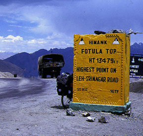
Our journey on this road took us further over the Lachulung La at 5065 mtrs (15904 ft.) to Pang for lunch. Getting hot lunch at 4650 mtrs. (14600 ft.) was surely a luxury. But something very unusual happened here. It started to snow. Snow flakes came and settled on our windscreen and then came a heavy downpour. It was raining in the cold desert and life suddenly came to a standstill. There were two Swiss cyclists headed for Leh from Manali. They were wet to the skin and were freezing. The warmth of our vehicle made them comfortable. They swore that no book ever told them to be prepared for snow and rains in the desert. Our vehicle in the meanwhile had a little difficulty in the slushy conditions of the road undergoing repairs. The rains continued through the journey. We were soon approaching the world’s second highest motorable pass of Tanglang La at 5360 mtrs. (16830 ft.), where snow took over again. A layer of white surrounded us - till where the eyes could see. It was the most amazing sight. However, getting off the vehicle was close to madness – with the cold winds blowing – almost as if all the way from the North pole.
As a result of these extreme climatic conditions and paucity of rainfall, compounded by very poor agricultural produce - this area has one of the lowest population densities in the world- just around two per sq. km. But it is surprising how those people who live here actually manage to live. Karzok a small village at 5000 mtrs. (15700 ft.) near lake Tso Moriri is considered to be the world’s highest in-habitated and cultivated place. Many of the residents of that region are nomadic herders known as Changpas. The town of Dras, made famous by the Operation Vijay at Kargil, has the reputation of being the second coldest inhabited place in Asia with the temperature dropping to as low as fourty degrees below freezing.
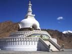
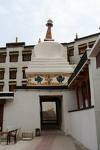
Image: Shanti Stupal
Late in the evening, we drove into the comfort of Hotel Mansarovar at Leh for our stay. This was to be our home for the next six nights. Leh was already asleep by nine and the streets were deserted. Infact it was only in late nineties that Leh actually got its street lights.
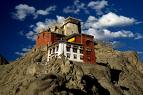
Next morning woke us up to a spectacular view of Leh – nestled between barren hills is the green tree covered city. Overlooking the city is the Leh Palace, a nine storied monument built in 1630 by King Sengge Namgayal, in a style very similar to the Potola Palace of Lhasa, which infact the leh palace antedates by fifty years.
Leh was also a major hub for the trade route between Punjab and Central Asia and Kashmir and Tibet. Even today, you could see that the streets of the main bazaar were wide with broad kerbs, designed to felicitate the passage of caravans of horses, donkeys, camels and also provide room for display and storage of merchandise. Traders brought in Chinese silk, Indian tea, spices, pearls, gold, pashm wool, salt, opium, carpets and even Varanasi brocades.
Today, these traders have been replaced by modern shops and curios. Plastic money has replaced the barter trade. The Central Asians have been replaced by adventurous Europeans and people from more far away lands. But the old charm of these streets still comes alive in the evenings when the women from the nearby villages come to sell their fresh vegetables.
The old Leh town is still the same with maze of narrow allies with Chortens and cluster of flat roofed homes constructed with sun baked bricks and plastered with mud. However, this is a cause for concern. The changing climate has meant more rains, which is causing degradation of many of these mud structures. One of the noticeable features of these homes and for that reason many important features like the Leh Palace is that they are not painted and merge very well with the local landscape. In contrast, the defense establishments with their typical camouflage patterns painted on them stand out in the earth grey surroundings – so much for trying to become invisible from the enemy.
Diskit Monastery © AChaoji 2008
Infact historically, it was only during Zorawar Singh’s two expeditions that Leh had actually seen much of the war machinery. The thirty two Rajas of Ladakh who ruled over eight hundred years had more or less seen a very peaceful period. Zorawar, who was the General of Jammu’s Gulab Singh’s army, moved in to bring Dogra rule in Ladakh. As a result, the erstwhile ruler Gyalpo was ousted from the royal Shey Palace and shifted to Stok village, which was given to him as a Jagir in 1834. The son of the last king, Choegyal Jigmed Wangchuk Namgayal still stays at the Stok Palace. Later, it was in 1947, when Kashmir was acceded to India, that the Pakistani forces occupied parts of Ladakh and so did China occupy Aksai Chin. Ever since, this region has always been very sensitive.
But for a major part of its existence Ladakh has had a very peaceful past. The numerous monasteries, or Gompas as they are called, have been centres for learning, culture and spirituality. Even today, the commonest signs in Ladakh are the prayer flags fluttering in the winds, elderly folk carrying their prayer wheels, Chortens inset with stone slabs carved with sacred invocation of "Om Mani Padme Hum", which literally means – hail to the jewel in the lotus. However the true significance is much wider and calls for a deep understanding of the faith.
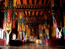
The walls of the numerous Gompas are decorated with the manifestations of each divinity of the Mahayana Buddhist pantheon and the Bodhisattvas, who like Lord Buddha also attained enlightenment, but were willing to forgo Nirvana so that they could guide others to obtain liberation from endless rebirths.
We began our Leh exploration with the Hemis Gompa, located almost hidden behind the mountains. This is the largest and the richest Gompa in Ladakh. It was also founded by the Leh Palace builder King Sengge Namgayal in 1630s and ever since this Gompa has been the most favoured by the Namgayal dynasty. The annual Hemis festival is dedicated to Guru Padmasambhava, the 8th century reformer who brought Buddhism to Tibet. However, most of the scriptures had to be translated to the Tibetan script and this was done by the great translator Rinchen Zangpo.
Like most other Gompas, Hemis is also situated on a hillock. Its upper part comprises of temples called Lhakhang, assembly halls called Dukhang together with the temple of the fearsome guardian deity called Gonkhang. Each Gompha also has an impressive collection of books in the form of loose sheets tied together between wooden boards and wrapped in silk. Many of these are a few hundred years old.
The dwellings for the monks are on the lower slopes. Monks, also called as Lamas, in many sects have to live as celibates to observe strict discipline to set examples of pure life, selflessness and tireless dedication to their noble mission. Traditionally, a family with number of children sends a son or daughter to the Gompa to go through several stages of Lamahood. Girls initiated into religious lives are called Zomas and live in nunneries. However, they are free to get married. Head of each Gompa is addressed as a Kushok. The title of Rimpoche may be given to the Kushok of a large Gompa. Since they don’t marry, they have no heirs. Thus when a Kushok dies, his successor is found in the form of a new incarnation. It is believed that before dying, the Kushok indicates where the new incarnation will be found.
Amongst the other Gompas that we visited included the impressive Thiksey. This Gompa is famed for its beautiful temple to Maitreya, the future Buddha. The Gompa at Lamayaru, on the road to Kargil is located on a hillock overlooking the moonscape – an eroded landscape with spectacular formations. This Gompa was constructed in the eleventh century.
One morning, I drove up to the fifteenth century Spituk Gompa. This is the oldest Gompa of the Gelugpa sect. His Holiness the fourteenth Dalai Lama belongs to this sect. As I reached the Gompa, it was the time for the Lamas to offer their morning prayers. The two hours that I spent in the resonating hymns brought an absolute peace of mind to me. I think I will never be able to experience that tranquility ever again. But the Gompa that I was specially waiting to reach was Alchi. Set on plain grounds close to the Indus river, this Gompa was built to commemorate the revival of Buddhism in the eleventh century.
The other Gompas too that we visited, left an indelible impression on us. The peace of mind attained by meditating in a Gompa cannot be compared to any other worldly experience. However, this visit to Leh would have been incomplete without being fascinated by the Pangong lake and the land beyond the Khardung La – the Nubra valley. The valley of Shyok and Nubra rivers has spectacular sand dunes and the unique double humped Bacterian Camels.
But for some unknown reasons, this Gompa was closed for regular worship in the sixteenth century. As a result, the Thangka paintings of the entire Mahayana Buddhism cosmology have been spared of soot from the yak butter lamps and intense sticks and are thus in a good state. Dukhang, the oldest of the complex has a beautiful central image of Vairocana – the main Buddha of meditation. The second oldest temple of Sumtek has Avalokiteshwara – the Boddhisatva of compassion with intricate miniature paintings on his legs. On one side is the image of Manjushri, the Boddhisatva of wisdom, who is shown with a flaming sword which cuts through the fog of ignorance. And on the other side is the image of Maitreya, the future Buddha.
By the time, I was flying out of Leh airport, I felt that I had left behind a part of me, yet I was carrying so much more with me in the form of sheer experience and understanding of life. As the aircraft flew close to the Spituk Gompa, I was telling myself that very soon I would be doing this pilgrimage again.
© Anirudh Chaoji December 2008
website:
www.pugmarksholidays.com
www.pugmarksecologix.com
© Hackwriters 1999-2023
all rights reserved - all comments are the writers' own responsibility - no liability accepted by hackwriters.com or affiliates.