![]()
|
Index
•
|
|
Welcome
•
|
|
21st Century•
The Future |
|
World
Travel•
Destinations |
|
Reviews•
Books & Film |
|
Dreamscapes•
Original Fiction |
|
Opinion
& Lifestyle •
Politics & Living |
|
Film
Space •
Movies in depth |
|
Kid's
Books •
Reviews & stories |
|
|
|
|
The International Writers Magazine: Motorcycle across USA
The search for Crazy Horse (3268 Miles later)
• Harlan G. Koch
Tom Newland and I seldom have specific plans for our motorcycle forays beyond the High Sierras; however, this trip covered so much it demanded a plan of sorts. Quel temps fait-il; temps fait mauvais. This time, in our effort to accent history and geology, we wanted to actually "see" wagon wheel tracks and pony express stations. At Wyoming’s Independence Rock we wanted to see the actual proof of pioneer names and dates carved into stone, we wanted to better understand why the Oregon-California trail was called the world’s longest graveyard...
The estimated 10 deaths per mile were chiefly due to cholera. Ours had been a migration so intense that it was bound to conflict with the numerous hostile Indian tribes, tribes which were too often misled by dishonest treaties and by any acceptable Code of Honor.
We wanted to "drive through" South Dakota’s magic Black Hills, a sacred area to Indians, filled with animals (mountain sheep, bison, deer) grazing the shoulders of the road. Sturgis was also on our list; it’s a motorcycle town that annually invites thousands of bikers to take over. We’d then go on to artsy Spearfish and into Sundance, Wy. Sundance’s only advertised claim to real fame is its geography and that its county jail once housed the infamous Sundance Kid. Chief Crazy Horse was born near Sundance at a place called Bear Butte. Perhaps we can find it.
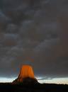
We intended to skirt by the base of Devil’s Tower, a sacred spot the Indians called Bear’s Lodge. It’s a classic example of a volcanic neck and also the nation’s very first national monument. Imagine … it was established by Teddy Roosevelt! Then westward via Gillette and Sheridan, and then up to Montana’s great grassland. We’d reconnoiter the historic Rosebud Battlefield and Custer’s somber National Monument on the Little Big Horn: also established by President Teddy Roosevelt. This was an area where Indian hunting grounds had been usurped and the ongoing conflict had provoked some of the most vicious battles between Indians and whites. We’d spend the night at Billings and then follow the Yellowstone River down through Montana to our nation’s first national park at Yellowstone. We’d spend the night at the Old Faithful Lodge.
On our way home we’d exit Yellowstone’s south gate to see the majestic Grand Tetons and visit famous Jackson, Wyoming. If our trip were truly blessed we might even meet Vice President Dick Cheney who would surely invite us in for cocktails. Farther down the road we were looking forward to what Life Magazine described as Nevada’s "Loneliest Highway in the World." Beautiful Route 50, the pony express route across the middle of Nevada and also known to the Wagon Train masters as the Central Overland Trail from Salt Lake to Sacramento. All this combined surely heralded an unforgettable Western trip!
We wanted to know more about the intrepid trail bosses or wagon train masters and their gritty leadership. There were so many of these colorful characters that they would require a thick book of research. Two of the most notable progenitors: Lewis and Clark (1804) were followed by iron men like Jedediah Smith of upstate New York. In 1823 a grizzly bear mauled Smith not far from Sundance, Wy, ripped off one of Smith’s ears. Imagine the pain when Smith ordered a member of his team to suture the ear back onto his head where it belonged and without morphine sulphate’s sedation. This same Smith spent 44 days crossing the Great Basin and in 1828 Oregon Indians massacred most of Smith’s party. Smith escaped. Comanche Indians finally killed Jedediah (probably painfully) in 1831 on the banks of the Cimarron River not far from my Oklahoma hometown: Waynoka.
It was a great setting for a Western trip, 3268.1 fabulous miles and from our several prior experiences it was certainly doable even if we were planning a late departure. Tom, was my usual special partner because he never gets lost and is no tyro to exploration and discovery. He and his small group once walked … imagine … the Pacific Crest Trail from Mexico to Canada, an extremely tough trek to match. All we’d need for success was that our bikes not mechanically fail us, and for us not to fail the bikes on some challenging mountain curve, or, for an errant trucker or high leaping stag not do us in, and among the most important: for fairly decent weather to be with us. We were aware that 12 September was a late departure, perhaps a week to ten days late in our so-called ever-narrowing window. We carefully blotted this rationality from our discussions.
In retrospect, ours paralleled the same late-start nemesis that had crushed the hapless Donners during the 1846-1847 blizzards. Most of that party had died in 22 feet of snow and even more grisly, when their food gave out they commenced cooking and devouring the ghastly frozen remains of each other! The Donners became one of the classic horror stories across the High Sierras. And, as if to nag at us, our highway I-80 ran a bare few thousand feet above the site of their horrific winter at Donner Pass and Donner Lake.
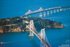
12 September we departed San Francisco at 0900, crossed the newly-surfaced Bay Bridge, then veered northeasterly on I-80 via Berkeley, passed over the new Carquinez Straits Bridge and skirted Vallejo. It was a cool 60 degrees. By 1117 hours we had traveled 130.4 miles and had climbed 1255 feet to where the temperature was now a toasty 95-degrees. It felt grand. We figured we were getting 48.65 miles per gallon—that’s two cents per mile—and our average speed up the mountain was 57.1 mph … pretty great progress for Mr. Harley and Mr. Davidson. After 70-plus more miles we would cross the High Sierras. The tanks of each motorcycle holds 4.5 gallons but there’s no gauge! Tom and I "roughly" figure that a half tank will take us 110 miles. The 110 miles is the signal to commence looking for a service station. Imagine! All that expensive glitter on motorcycles and they delete a fairly inexpensive gas gauge.
Months ago while reconnoitering Nevada’s fabled Area 51 adjacent to Extraterrestrial Highway (There are such great names in Nevada), we left isolated Tonapah, Nevada (El. 6256), without topping off. Only four miles east of town a lonely sign read: Next Gas 80 Miles. We immediately returned to Tonapah. There’s nothing worse than to sit beside a deserted desert road on empty talking to curious horses bulging with methane. When we arrived at Rachel, NV, the Land of UFO’s and also tangential to America’s spooky Area 51, we limped across Coyote Summit and beyond Reveille Range on our reserve. Being on reserve in the desert is guaranteed to spike a rider’s blood pressure. Parts of the desert’s deviltry are those steep grades and headwinds. These can surreptitiously change the planning figures. Rachel is the spot on the map where urban thrill seekers from as far away as Vegas lay on the sleepy road and beer in hand they stare into the starry glitter till dawn. They watch for itinerant UFOs because there is a gamblers chance. After all, this is Area 51; it’s different, if there’s really a UFO it should be here.
Exactly four hours and 239.5 miles after leaving San Francisco we stopped for gas at Sparks … a suburb of Reno, Nevada (El 4410ft). This was Winner’s Corner, a great name for Nevada but not for the pancaked car just towed in. We were spared seeing the passengers the EMT had already removed to another location. Since leaving San Francisco, our average speed was 59.87 mph which includes all stops. We were moving right along. Like old men, we unglued ourselves from our bikes, stretched our butt muscles that felt numb, shook out sore wrists and drank Tom’s Gatorade. We’ve long been aware that shaping up for long rides takes at least four road days.
After leaving Sparks, we edged into the warmth of the beautiful Nevada desert. This is America’s Great Basin, a 190,000 square miles of desert—America’s largest. During the Pleistocene Epoch this basin was the location of the great Lake Lahotan which during its last 10,000 years had mostly dried out. Deserts of this aridity are among the most fragile ecosystems on earth, so dry the cacti are special and stunted and the sage hasn’t the same penetrating fragrance as sage in most Western states. I wondered if these 10,000 years of melting the Pleistocene ice and the desiccation of Lake Lahotan are what our greenie activists might perceive as hints re the nasty global warming syndrome. Did all this melting and evaporation commence long before Kyoto’s establishment? Or is this condition probably not a new warming condition. Let’s suppose then that there have logically been several Pleistocene Epochs.
When we arrived at Jim’s Chevron at 1927 W. Winnemucca we had traveled 360 miles for the first day, the temperature was 108 and after San Francisco’s daily 55 to 65 this high dry place was marvelous. Coming into Winnemucca (Pop. 7700, El. 4299 ft), a large cemetery as neat as a public park is to the immediate right of the road. Pit stop: 2.99 gallons at $3.36 ($10.04). The Best Western desk people told us telephone calls were on the house because their computer system had broken down. This is the hometown of Minor Lee Kelso my USMA ’46 classmate. No matter where I go, Hong Kong, Angkor or Mombasa, I find some part of ’46 virtually everywhere.
13 September 1217 hours, temperature 97: we notice our elevations are rising. We have traveled 185 miles to Elko (El.5067 ft.) Weather harbingers such as these guarantee a successful trip. We stopped at Elko’s Winner’s Corner Chevron for 2.999 gallons ($3.359 regular; 61.67 mpg). Our Route 80 follows the trace of California Trail wagon trains; the Humboldt River borders to our south. The Southern and Union Pacific railroads also follow the Humboldt River lowland (Look up this remarkable Alexander von Humboldt, his adventures make ours look as elementary as possible). In the Nevada Desert we often saw what appeared to be abandoned, crewless 90-car freight trains left shimmering in the desert, and, with no noticeable crew. We wondered if these were secondary parking spots because there were no available marshalling yards.
Second day: 514 miles from San Francisco.
In the Great Basin the Humboldt and other streams flow to no ocean. In the Basin’s West the Humboldt just silently disappears in the Carson Sink while the East part of the Basin gurgles its last in the Great Salt Lake Desert. Fascinating geography.
Left Elko at 1315 hours. Went through Wells (El. 5653 ft.) and crossed the Pequop Mountains at 6967 ft. Nevada has a proliferation of narrow mountain ranges that generally run NNE to SSW. The Southern and Union Pacific railroads are quite busy along here.
Arrive at Wendover on the Utah border. To the left (north)is the famous Bonneville Flats, elev. 4236 feet. We are now 662.5 miles from SFO and have averaged 61 mph from Elko. We fill up (2.484 @$3.099/gal) at Bonus Star Mart. We have looked forward to seeing Bonneville. Up to 1935 it was where Sir Malcolm Campbell had raced his powerful Bluebird cars and set nine world records; I remembered it from Movietone News shots at this same Bonneville spot. Now I was actually there and was being internally thrilled. Only recently I had seen Sir Anthony Hopkins in "The World’s Fastest Indian" (a true story) that had recently been filmed here. Hopkins played a senior motorcyclist who traveled from New Zealand to California on a tramp steamer with his renovated junk bike. He came to Bonneville to establish a world’s speed record. He did! And, the old man and his ancient Indian returned on subsequent years to establish even more records.
At Bonneville we gassed up at 4:35 PM(lost an hour). Temp is 103 degrees. Surprisingly, we had no problem with today’s heat because our own dehydration had both fooled and pleasantly cooled us. Unknown to us, this would be the last hour of our warm weather until we returned to San Francisco. To our East, the clouded Wasatch Mountains formed the skyline – some of the mountains are 13,000 ft high.
We drank Tom’s Gatorade and shot eastward across the mesmerizing white Great Salt Lake Desert … the road was arrow straight. Signs on the shoulder frequently warn motorists not to drift off to sleep. We passed just north of Kennicot Copper, the world’s largest open pit mine near Tooele. We could see at the base of the distant Wasatch Mountain range a long freight interminably lacing its way from south to north. Arr Salt Lake City (El 4260 ft. Total mileage for two-days ride from SFO: 800.5 miles. 440.3 miles for today. Pit stop at the Top Stop, 2603 Parleys Way SLC. 2.64 gal @ $3.03/gallon.
We quickly discovered that a conference had turned Salt Lake City into a mess. Visitors were crawling out of every bus and airplane to fill the motels. We found a little dive operated by a Korean couple; she allowed us to park our bikes next to her office door and offered us a free cold beer ... a jolly greeting unusual for Morman Salt Lake City. It’s always bad procedure to arrive late. Even in towns traffic becomes reckless as travelers charge in to find accommodations.
14 September: On the third day from SFO we depart SLC 0730 on I-80 and head into the Wasatch Mountains; the temperature is chilly as we commence our climb toward chichi Park City. This is where the Sundance Film Festival is held in January, NOT at Sundance, Wyoming. It’s ski-country cold. In the steeper parts of the mountains, we ran into a couple of chilly showers. Not too smart driving a high performance bike on wet, glistening asphalt, especially when at this elevation ice can be an unwelcome surprise around the next sharp curve. We’ve gained considerable altitude these early 57 miles.
Small town to the right ... we’re cold and turn off I-80 to Coalville, UT (El. 5586 ft.)to allow the air to warm up a tad. Pit Stop: 1.625 gal @ $3.05/gal. This is a friendly little town located 857.8 miles from SFO. We followed the town marshal’s best advice for the town’s most popular breakfast nook. We each ordered three eggs over easy, pancakes, and delicious hash browns. We headed due east with I-80 climbing relentlessly higher to Evanston, Wy, (El.7163 ft) and on into Fort Bridger’s (6670 ft.). This is the high rolling plains country.
Tom’s on a geology kick this morning. The relentless drizzle has slacked off but the weather shows obvious signs of deterioration. Tom’s photographing everything. This is good because I’ve become jaded and have a tendency to bypass those one-too-many historical sites. For example, in the past I would travel a mile down a side road to see the historic stage and livery only to discover nothing more than just another bronze plaque. With only ten days to travel we have to prioritize by limiting unworthy stops. If we had loads of time we could futz around but Tom has a fire station to return to and I have Judy and Lucy the cat.
More interesting to us was where was this Fort Bridger and who was Bridger? This time a worthwhile sign came to our aid:
Note that Fort Bridger is at exit 34 of the I-80 highway in the southwestern corner of Wyoming. A key to Ft Bridger's success was its location, a spot that had plenty of trees and fresh water. Bridger, the man, had been one of the most famous mountain men in the West. In his earliest days, he had discovered the Great Salt Lake; he helped blaze new trails across the West. In one of his many adventures he had taken an arrow in his back. Three years later they removed this arrowhead without anesthetic. (Recall Jedediah Smith and the reattachment of his ear. Also, remember those old Westerns where the "Doc" was always excising a bullet without benefit of pain killers.) It was this same Bridger who at Salt Lake tasted the water and declared, "Hell, we are on the shores of the Pacific."
The Bridger Trail, especially along the Platte in Wyoming and in Utah, is prominent among the most popular routes. Along one of these traces, 157 Pony Express stations (a fresh horse every 15 miles) were established from St. Joseph, Missouri to Sacramento. The intrepid Pony Express riders galloped the mail from St. Joseph, across Nevada to California in ten days. Read Mark Twain’s "Roughing It." It was his account of traveling this same route that is considered among his life’s best work.
During this same exciting time, cities were being made. For example, Denver emerged as a notable transportation, meat packing and trading hub. With the completion of the transcontinental railroad in 1869, wagon travel began to decline.
Pit stop at Rock Springs, Wy (El.6271), we are 1004 miles from San Francisco. 1215 hours. 3.14 gallons from Coaltown, UT. There is a strong southerly wind that threatens us with serious rain. Tom and I tried to determine which of us had decided that September was too early for rain in The West!
We zoomed by the old Granger (El.6240) Stage Station; it was very near I-80’s exit 130 near a town called Point of Rocks (Elev. 6509 ft). It was a relay point for the Ben Holladay Overland Trail Stages (Great Names) in 1862.If you’re short of time there’s perhaps too much to see. Lewis and Clark and von Humboldt took months to explore; like everything today, we only had ten days. Unfortunately, the Holladay stage stop was reportedly a piece of history we should not have bypassed. Perhaps on a later trip.
Enter Rawlins at 1511 hours. Pit stop; we’ve come 1120.5 miles from SFO. Top off at Rawlins’ Perkins Conoco with 2.371 gal. Incidentally, during the entire 3200 mile trip we used no oil nor did we add or reduce air pressure. Depart Rawlins from I-80 and head due north via Whisky Gap to see historically important Independence Rock (very worthwhile historical site).
Reached Independence Rock; there is no gas facility. It is 1188.3 miles from SFO and 68.3 miles north of Rawlins. This granitic monadnock is among the most important landmarks on the California-Oregon trail. Often called The Register of the Plains, it is a solid loaf of rounded granite that can be seen for miles ... especially from the northeast. Thousands of migrants and their wagons encamped on the flat plain overlooked by "the rock". There they fed their animals, made repairs and wrote or carved their names’ initials on the surface of this tremendous granitic rock. Tom ran up the sloping rock at a rapid rate but the 6230 ft elevation finally brought him to his knees. Several, almost tame, fat cottontails hopped around at the base of the rock.
There’s a light sprinkle in the air; we continue on to Casper and arrived at 6PM (El. 5123)14 September. We encountered a half dozen deer grazing on road shoulder but thankfully none bolted. At 6PM we arrived at Casper (El.5123). This is Vice President Cheney’s hometown. We’ve come 1247.6 miles from SFO. Casper is a nice looking little city. Prominent sign on a government building reads: Dick Cheney Building. Across the street is the 8-floor petroleum building. Also here are Casper College, Univ. of Wyoming at Casper, 3 golf courses, Oregon Trail Veterans Cemetery (80,000 had made the trip by wagon), old Fort Casper, and the municipal airport.
15 September:[CASPER WY] Depart Casper for Lusk, Wy, at 0830 and arrive Lusk at 1028 hours. Pit Stop: 1.98 gallons Morning temperature is a perfect 73 degrees. Virtually no traffic through the grasslands; we have driven the 110.4 miles in two hours. When we reached Fort Robinson (beautifully maintained place) it was lunch time and only 3 miles to Crawford, NE. Once again, we didn’t take sufficient time for a Robinson stop. Arr at Crawford 1136 hours and 79 degrees. We can hear freight trains over the hill. Great little Mom’s diner at Crawford crossroad. We took on 1.234 gallons for $3.53. 1418.3 miles from SFO.
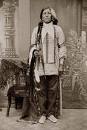
We learned that Fort Robinson was where Chief Crazy Horse was killed 5 September 1877. Fort Robinson is now a Nebraska Historical State Park which is administered by Nebraska University. The University maintains longhorn cattle on its fenced acreage and there appears to be student activity. Fort Robinson (Famous Indian Wars Army installation: 1874-1899) once housed a regiment of Buffalo soldiers. During the Indian Wars, Gen. George Crooks, USMA 1852, was the area commander of the Indians and made his headquarters at Fort Robinson. We learned that while Crazy Horse was incarcerated at Robinson an American Buffalo soldier bayoneted the chief when the chief reportedly had become excited at lock down. That was unfortunate. Chief Crazy Horse was one of this region’s most famous and colorful American Indian chiefs; Sitting Bull, famous Lakota Chief who lived 56 years, was one of Crazy Horse’s closest associates. We had wanted to learn more about Crazy Horse, his tribe’s hunting grounds and why Crook’s men found it necessary to jail Crazy Horse and later kill him at Fort Robinson while under U.S. Army supervision. We wanted to learn more about a possible broken treaty, and also view the progress of the huge Crazy Horse memorial now being painstakingly carved on a Precambrian mountain face near Mt. Rushmore. Unfortunately, the sun was low and rain was threatening. We moved north on Hwy 2 to Hot Springs,S.D. The Black Hills of South Dakota, sacred Indian ground, were just ahead. We were about to see Rushmore and the beginnings of the Crazy Horse sculpture. Evidently Crazy Horse is astride his horse and will eventually be on the same grand scale as Rushmore.
A BEAUTIFUL TRIP BEGINS TO UNRAVEL
We took a pit stop at Hot Springs, S. Dakota: 1.319 gallons for $3.91. Very strange weather, scudding clouds and weather is hot. We go north on 79, Black Hills are to our left front; the hills are not black but the contrast of the dark green pine trees make the hills appear black.
After finding Rushmore, the Park Service honored my National Park lifetime senior pass but the concessionaire wanted $8 parking for each motorcycle while we took a few photos in the rain. Tom shoots Rushmore shrouded in the clouds. It began to rain hard and as we left for Rapid City the temperature dropped rapidly.
We found the Crazy Horse sculpting site to be much the same scale and idea of Rushmore. The park people there were also happy to have us in the rain at $8 per motorcycle. We could see the "beginning" of a sculpture, could see the nostril of Crazy Horse’s horse but after years of work it was still not ready for serious viewing. Many slick turns and climbs and there were deer, mountain sheep, and a few fantastically beautiful chestnut buffalo along the sharp curves. Tourists are wet, misery reflects from their faces. They are camped in unditched tents with everything sopping wet … including my feet. Our bikes are mud splattered.
At our Rapid City, SD, motel the sun mercifully came out. We borrowed a hose to clean up our disreputable bikes, walked to a neighboring restaurant for a beer and delicious prime rib. Great service. Rain stopped and the sun’s now down.
Class of ’46 has a classmate at Rapid City who was formerly a professor at the South Dakota School of Mines: Josiah Wallace D-1. Regardless, in spite of the classmate entrée, I could never bring myself to call a classmate just before dinner: "Joe, I’m here with Tom, the friend of West Point." When we operated the stores in Honolulu and San Francisco it was surprising how many "old buddies" dropped in just at closing. We’d leave for our home in Tiburon before the big rush across the Golden Gate Bridge … à bientot bon ami!
16 September: Left Rapid City (El 3918) at 0849. This is mile 1602.7--we’re heading due West—and our farthest point from San Francisco! Ominous clouds put a chill (no rain or snow) in the air and gave us a beautiful sunrise. Take it from Tom and me: Be wary of beautiful sunrises! We were on I-90 heading West toward Sundance. En route we would stop at Sturgis, visit its great Harley-Davidson store. Sturgis is also the site of one of the nation’s largest annual motorcycle gatherings; they say, "thousands of bikes" take over Sturgis. We discovered at the motorcycle store that we were within seven miles of Bear Butte, the sacred land where Crazy Horse was born. We briefly futzed around at the Harley shop.
Today our master plan was to drive "through" Sundance (scan the sidewalks for Robert Redford), and see Devil’s Tower which is really "Bear’s Lodge." -- Bear's Lodge, located in northwestern Wyoming, is a towering 1,280 foot monolith long considered sacred by over twenty tribes in the Plains Nation. We were off via Gillette and Sheridan to Montana and to the famous Last Stand of West Point’s most famous goat, George Armstrong Custer (Last Man USMA 1861).
Today, 16 September, would make or break our trip. All we had to do was rocket down the road and drink in the scenery.
Unfortunately, all was not well in River City. While visiting Sturgis Harley-Davidson, the temperature had steadily dropped to 39 degrees and made bitter by a headwind that had picked up to 25-30 mph. As we proceeded West out of town, a cold driving rain commenced hitting us head on.
We stopped at a Hardee fast food; showed our gratitude by topping off with gas and going in for a hamburger. Our principal missions at Hardee were to thaw out and have lunch. If you’ve ever seen To Have and To Have Not with Bogart and Bacall, you may recall how Walter Brennan jerkily hopped around like a man with prohibition Jake leg. I entered Hardee’s in much the same way; I was just two degrees north of hypothermia.
Even though the food was delicious, we were not euphoric. Setting fire to the bikes, buying tickets on the nearest airline that went to either San Francisco or the Bahamas were both viable options. Neither of us wished to come right out and admit it, but it was beginning to dawn on Tom and me that a "plan fizzle" was threatening our master plan.
We ate the burgers, and left for Sundance but it was now mid afternoon. Our today’s plan for Custer was temporarily canceled. The right side of my right hand gave every indication of frostbite.
When we arrived at Sundance (El 4750) at 3PM on 16 September the temperature was 38-degrees and real snow was mixed with the 25mph horizontal drizzle. We checked into room 129 at The Bear’s Lodge. There was hard standing and special overhead protection for our bikes: $69/night. Kellie Kephardt, once of NMMI, was the affable manager. We arrived cold and with squishy footwear. At their handy laundry, we washed our bag of dirty clothes. To make them happy, we washed the miserable bikes, talked to Kellie, met the office dogs and cats (the office has all manner of animal heads, wild cat and bear skins, etc. I wondered if living in a place like this adversely affected the psychological state of domestic dogs and cats. I mean, you put yourself in the dog’s or cat’s moccasins.)
We put our miserable footwear in the dryer. Tom checked out a DVD from the office and 3 movies. One, not surprisingly, is Travolta as a fire chief. Not bad. That Tom-the-Fireman found it did not surprise me. No charge. This motel is advertised as a place of warmth. Tom went to the office computer to check out our rapidly deteriorating weather. Outside it was a little like the picture with Jimmy Stewart trying to bring his jet bomber in through the fog without clearance: "Kadena, I’m coming in!"
Across the street (Cleveland Str) is the "warm" ARO restaurant. We went over. Many antelope hunters are in town and are holed up in the restaurant, each with his beer and a few were from our very own Bear’s Lodge. Antelope hunting must take it out of you because the hunters were docile and sleepy looking. Tom and I had a good beery dinner.
17 September. This morning we attempt finding Devil’s Tower in the horizontal rain and snow but after a few miles we gave up—it’s just too cold, wet and dangerous. We enjoy the ARO’s passable food. Nice place to wait out a storm. Now the snow is thicker and blowing parallel to the ground; we’re both glad we gave up on Devil’s Tower. We want to leave Sundance’s low pressure area, perhaps we can still salvage the trip. Unfortunately, the weather’s too much.
We watched movies and occasionally Tom checked the computer for the weather situation. We watched the storm move in from the NW which is where we want to go. Tom and I discussed our options and we concluded that Montana was out, our entry into Yellowstone from the north was out, ditto for the Tetons and forget having cocktails with the vice president in Jackson. We might just as well slice off NW Wyoming … we’d lost too much time. Right now we should be riding adjacent to the wall of the Tetons looking at herds of elk and buffalo.
We had made "our own" Last Stand with a blizzard outside every bit as bad as the whiteout Mark Twain once encountered at Eastern California’s Mono Lake. It was all blizzard outside, complete with howling wind and possibly encroaching animals. All we had left of our initial plan was the Nation’s Loneliest Highway through the middle of Nevada. We had searched out Crazy Horse, found exactly where he had died in Nebraska. We were now suffering from his revenge! Crazy Horse had found us wandering in the southwest corner of South Dakota and we were his. We concluded that like the Donners, we had started a week late. Temperature at dinner is 37 degrees; snow is horizontal. We intend to withdraw right through Wyoming from the NE corner of Weston County to the SW corner at Evanston (El 7163 ft). Evanston’s 7,163 feet is feeling more and more like Pike’s Peak summit.
Just so that you know I personally was not beaten and that I had surely switched to "survival mode," before leaving Sundance I checked at a likely place for a buffalo skin coat. I thought that would be the greatest kind of trophy from this Nome-like experience. After all, some of today’s bizarre bikers wear the Brunhilde Nordic helmets with steer horns coming out each side. How about me tooling around San Francisco’s boulevards wearing a buffalo robe? How cool could I possibly get? Also, imagine me walking into Union Street’s chichi little Betel Restaurant or the laid-back Plumpjack hashhouse on Fillmore. The buffalo robe might even evolve into San Francisco’s coolest new fad; after all, San Francisco denizens had seen everything else. Practicality took charge. After all, a buffalo coat sells for about a thousand dollars. In spite of the storm, I wasn’t entirely brain-dead. In spite of my current wilderness milieu I was still aware that a camel hair beats buffalo robes for pizzazz by miles and miles. But then with a camel hair there is no there there. How many have really seen a buffalo robe? They’re actually quite warm? Absolutely perfect to wear on a stroll across the Golden Gate Bridge.
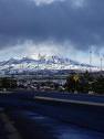
18 September: Sundance Mountain and surrounding hills are Christmassy white. The cars parked at Bear Lodge Motel were plastered with four inches of snow. Snow is on roof of the motel but it slides off and splats on the concrete twenty feet below. From I-90 and then Hwy 116, Tom and I venture southwest to Upton. The sky is a matrix of thick fog and swirling snow. Tom and I take picture of snow-covered field and hay. Even looking at it today makes my frozen hand hurt. Tom leads off slowly downhill through the weather’s cotton; it’s as if Tom is eerily disappearing straight into hell. Gradually, Tom is no longer visible. Wind gusts blow a chill up my left nostril; this ornery cold blast feels as if it is drilling right through the top of my head. A little later Tom reappears like the lead gossamer character in a séance. As the road deteriorated he had slowed. They have scraped the surface off the road and have left 3-inch deep grooves that grab at our front tires. Road turns to gravel; there can be no further surprise other than just pure mud. At Upton we turn off this mess and into a pit stop station. Again I have those Walter Brennan shakes and we’re 1738 miles from San Francisco. It’s 38 degrees and cloudy. Hands and face numb. Nice people here; we warm up in their convenience store and read the "Weston County Gazette" volume 92.The Upton High School Homecoming Queen is on the front page. Great store dog here, full of personality but then he doesn’t spend his day staring at a dead coyote’s head on his living room wall.
From Upton we have a blacktop road and at mile trip mile 1802 we begin entering what is locally called the Black Thunder Basin Coal Company area. Take photo of large (25) herd of pronghorn antelope. Sign reads: Report Those Shooting From Road. Imagine that on I-5 or I-95. Take photos of trucks with mammoth wheels hauling coal scraped right off the face of the Earth. Two trains: Santa Fe and Union Pacific on sidings waiting to be loaded. This is a bristling operation; power plant’s tall chimney about a mile into the field. Sixteen miles later we are at Wright which is a huge collection of mobile homes probably for employees of the Black Thunder Coal Company and the railroads. We turn SW at Reno Junction on Hwy 387.
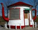
At 1539 hours 18 Sept we stop at Midwest for photo of Salt Creek Oil Field. We have come 71 miles from Upton. Wyoming’s Teapot Dome that became so nationally famous on 14 April 1922 is here; I had long thought it was either in Pennsylvania or Texas. Here is Teapot Dome alongside WY route 259 in what is virtually Jerkwater, USA, a handful of miles north of Casper. I would imagine this historic Salt Creek Oil Field is the reason for Casper’s 8-floor Petroleum Building. It is 5:30PM and we have limped 215 miles from Sundance. Forget any romantic aura … that communing with Crazy Horse will bring a show of sympathy. He had warned, "Do not stand at my grave and weep, I am not there, I do not sleep, I am a thousand winds that blow (he sure got that right), I am the diamond glint on the snow." I had it figured that we had been with Crazy Horse most of this morning and he had cunningly reciprocated with every imaginable weapon in his quiver, along with loads of glinty snow. It’s okay Crazy Horse! We white men understand, we are leaving, you should have been pestering Buffalo soldiers and not us. Check into our Casper motel at 1730 hours. At 1812 we have a micro brew and rare succulent prime ribs at Poor Boy’s Steakhouse. What a day!
19 September: Lv Casper 1926 trip miles in SW direction at 0840 on hwy 220 via Alcova; temp is 55. Pass Independence Rock at 1985.3 trip miles. This should be the last time we shall ever see it. How many 49er travelers must’ve said the same? We’ve been traveling WNW in the sparsely populated High Plains. Snowy white continental divide in the distance; arrive Jeffrey City North of Green Mountains. 2029 trip miles; pit stop at Split Rock Café 2.544 gallons. Traffic almost nil in this area. Map indicates 123 miles to Farson with few human footprints in between.
Turn left off 287 and southwest onto 28 and climb over the historically famous South Pass, 8110ft (continental divide) toward Farson’s unfriendly gray sky. We must be low on gas! I can feel a defiladed Crazy Horse lurking. The bleak little farming settlements lend virtually no possibility of kindly rancher gas. Hwy 28 west of South Pass is fairly straight and very lonely. Why aren’t there any UFO’s? At 1403 hours, thank God we made it to FARSON!
At this moment, arriving at Farson was better than the Golden Gate Bridge. 2152 trip miles. Cold – cold. It comes as no great surprise that the family operators of the Farson gas pump-grocery are Nepalese Sherpas! Of all the earth’s people, these people certainly deserve this place! God finally got it right. After unwinding myself from atop my Harley seat, I revert to my Brennan Hop as I walk-hop around to thaw. I watch Tom’s regal unseating performance. He reflects a quantum increase of élan and spirited vigor which is precisely what thirty fewer years will do for you.
Pit stop 2.64 gallons ($3.099/gal) at Farson is operated by Nepali couple (At 7000 windy feet only they would have found this windswept investment). I wonder how some gaunt-eyed realtor must have written the wily classified ad that eventually captured this family. Possibly he called it "Everest" or even "The Kathmandu". Yes, that might have done it! Anyway, the little rosy-cheeked Nepalese boy is not whining; he and his dog thrive on this miserable place. Hot soup, chili or chocolate would have surely elevated this place into some world travel 5-star magazine. Instead we drank an icy coke and pay our bill which simply reads: Shell at State Hwy and Hwy 191 Still, we remember this place over most the others. The pumps weren’t set in concrete; they were surrounded by unmanageable loose gravel.
Farson to Ft. Bridger 120.5 miles. Pit stop: 2.438 gallons
Arr Evanston (see the southwesternmost part of Wyoming--). Check in at Day’s Inn at Evanston. Windy and brittle all day; today we drove 375.0 miles from Casper to Evanston which is only two or three miles from Utah.
Bikers notice: On the advice of a highly-regarded Lawrence Livermore scientist, Tom and I generally used low octane gas on this trip. The doctor declares the requirements for high octanes are pure bunk. He must’ve had it right because for 3268.1 miles my Harley never once did a "ping" (pre-ignite) and the low octane certainly didn’t affect speed, starting or immediate response. About every fourth tank I’d use the 90 octane just to clean plugs. That, too, was probably unnecessary but meant only to please the motorcycle gods.
20 September: Awaken at Evanston, Wy (El 7163 ft) at 0600. Both Crazy Horse’s and now Custer’s ghost continue to haunt and flaunt us. While having waffles for breakfast the snow swirled outside our window. Five blackbirds are pecking on the snow-white motel lawn; they refuse to fly in this weather. Heavy Kyoto-style snow with Morgan dollar-sized flakes.
Fantastic! We can’t go anywhere. This is another day that Tom will check the computer for our elusive weather "window" with no discovery. The major problem is that Evanston, although nice, is Dullsville.
21 September: The next morning (snow) we told the desk we will stay an extra day (2301 trip miles) but by noon the weather lifts. We checked out. This then would become the most dangerous day of the trip. We drive by Coalville (where we had had breakfast seven days before.) We plan to drive via Heber City to the Orem-Provo complex on I-15. We encounter terrible traffic together with driving rain and major highway construction. We head south paralleling the Wasatch Mtns. Up ahead I saw the awesome funnel of a cloud let down for a few minutes and then swallow itself back into its roiling blackness. Highway poorly engineered; the exit ramps are so short that cars are left standing on the freeway when red light below halts exit. Someone will eventually figure it out. Pit stop: Heber 1525 hours and 2377.6 trip miles. 2.233 gallons @$6.97; We arrived in Nephi (biblical name), UT, at 1750 hours. Our motel operated by a man from Bombay. Today was a constantly dangerous highway experience.
22 September: This morning we take Highway 50 (travel via Border, Ely, Eureka, Austin, Fallon and Sparks-Reno). As it is a beautiful route and encounters exhilarating terrain, we’ll save this route description separately. It’s worth buying a motorcycle just to experience Nevada along this route! Highway 50 climbs over a statewide succession of 7000-8000 ft. passes and from each lofty pass the road drops down into a huge beautiful valley where the road becomes arrow straight often for twenty miles. Then exits the valley and climbs beautifully to the next pass. There are no animals, few cars. Fabulously stunning country and we cruise at 90. I will save that route description for another report. Tonight we will stay at the Fallon Naval Air Station at nearby Reno. Fallon N.A.S. is having Top Gun graduation to honor ten young pilots, prime rib dinner; with Rear Admiral Emerson as our host. It was a gala affair with all the base officers present in flight-line dress. I looked into the huge bar mirror and notice how my face is wind-seared red. I frighten myself. I look as if I’ve been hanging onto this bar stool for three or four days. I hope I don’t make a bad impression on the young Top Guns.
September 23 Have breakfast at Fallon’s Harrah’s Casino and immediately head toward the High Sierras.
From Fallon we took off via Reno (Alt 50 to I-80), Donner Pass and Sacramento to San Francisco – today, a real 49er route, will be 305.8 miles at an average of 58 mph "including" pit stops). Tom is leading off by 100 yards and driving like a man possessed. Tom is not careless, he’s an excellent driver. In the interest of safety, Tom and I increased our distance from each other because of the heavy and fast traffic. To go slowly on I-80 is an invitation to disaster; our aim is to keep up with the NASCAR I-80 crowd. From Fallon to SFO we rocket down the Sierras in 5 hrs 15 minutes: an average of 58 mph "including" pit stops. The Fallon, NV to SFO leg completes the 3268.1 miles for this entire motorcycle trip. Awesome crosswind that averages 56 mph around flat Fairfield, (Travis AFB) CA, becomes a constant struggling contest just to keep the bikes on the highway. One semi-trailer truck, fortunately on the east-bound side, was blown on its side across the freeway.
This was indeed the day we had planned to return to San Francisco. Unfortunately, it did not include Montana, Yellowstone, The Grand Tetons and Jackson Hole: C’est le temps. Congratulations to Nevada’s loneliest highway; it must be among the nation’s smoothest; beats California’s highways in every direction. Pit stop at Truckee 3070 miles; pit stop Roseville 3155 miles; bypass Fairfield which is always a hassle. Today at Fairfield the wind was blowing from the south at "check-it," 56 mph and warm. We arrive home at Pacific Heights, 1530 hours 3268.1 miles.
One of the grandest sights that handily beat South Dakota’s Black Hills, Wyoming’s Wind River Mountains, and Nebraska’s remarkable mix of prairie grass and bluffs was coming across San Francisco’s newly-renovated Bay Bridge at 1530 hours (this is not the Golden Gate) and to see the truly glistening beauty of San Francisco rising majestically from the ground. In spite of its regrettable politics it is one of the most preternatural cities of the world that literally reaches out and grabs you. I couldn’t limit the huge smile that spread inexorably across my face. Coming into this beautiful city was one helluva conclusion. Home: We drove 305.8 miles today at an average of 58.3 mph including the excessive pit stops. They were pit stops, we did not dawdle. Unfortunately, we found it impossible to meet our plan. That guy Captain Ahab had nothing on us. Weather surely screwed us out of Montana and Yellowstone. Without dog sleds or a helicopter there was no way to make the itinerary. It’s a wonder we’re not still somewhere in Wyoming. It was that loathsome weather window and the uncompromising, unrelenting spirit of Chief Crazy Horse. We started our trip two weeks late and the Chief would never forgive us for our effrontery.
© Harlan G. Koch, Ret’d U.S. Army, Feb 2008
Winelda at alum.calberkeley.org
SINKNAVY46 at aol.com
Born near Wichita, Kansas, schooled in Oklahoma, (West Point) New York, (Champaign) Illinois, and at (Berkeley) California. First motorcycle 1946, last motorcycle 2008; Marathoner and Parachutist. Judy and I reside in San Francisco with, Lucy, a fabulous American Shorthair cat.
More USA Travel
Home© Hackwriters 1999-2008
all rights reserved - all comments are the writers' own responsibiltiy - no liability accepted by hackwriters.com or affiliates.