![]()
|
Index
• |
|
Welcome
• |
|
21st Century• The Future |
|
World
Travel• Destinations |
|
Reviews• Books & Film |
|
Dreamscapes• Original Fiction |
|
Opinion
& Lifestyle • Politics & Living |
|
Film
Space • Movies in depth |
|
Kid's
Books • Reviews & stories |
|
|
|
|
The International Writers Magazine - Our 23rd Year: From Our Archives
North to Alaska - Parts Five to Eight
• Sam Black
We left Jasper National Park at 0600 hoping to find a bear early in the morning. We are on highway 16 or Yellow Head Highway heading northwest out of Jasper. The scenery is simply awesome regardless which direction you look. We passed through Pocahontas, Alberta where you can visit Miette Hot Springs, bathing suits and towels for rent. Mike thought the air was a bit chilly.We saw lots of goats and sheep along here as they have a mineral lick to bring them close to the highway, but no sign of any bears.
A small tidbit for you: Yellowhead was named after an Iroquois trapper and guide who worked for the Hudson Bay Co. in the 1880’s. The trapper had yellow hair.
We turned left onto highway 40 or Big Horn Highway taking us to Grand Prairie.
We drove through Grand Chache, Alberta which is 132 miles from Jasper. The time is noon already, but stopping and looking at wild life and taking pictures of the magnificent scenery takes time. Oh well we are retired. What’s the hurry?
Grand Prairie is located at junction 43 and 40 with a population of over 44,000 people. Grand Prairie is the hub city for Northwestern Alberta and Eastern British Columbia. We headed out of town on highway 43 in a northwestern direction.
We crossed into British Columbia by late afternoon heading for Dawson Creek, BC. When we arrived at Dawson Creek, population 11,800 it had rained very hard earlier in the day and water was standing everywhere. Dawson Creek looks like something out of an old Jimmy Stewart western. As we drove through we were in awe of how old things looked and wondered if a gun fight would erupt at any moment. We located an RV Park right in town. We pulled into Tubby’s Camp Grounds and when I stepped out of the RV the water was four inches deep. The campground was gravel and mud and it was very difficult to distinguish between the two.
We parked our motor home and the sun came out and warmed things up quickly at an elevation of 2186. Cocktail hour began and ended an hour later when I thought of cleaning the RV at Tubby’s RV wash right on the property. The bugs and dirt were ground in along with the wolverine hair that was still attached. The mud at the park was still around, but the water soaked away.
Dawson Creek was incorporated in 1958 and has 19 motels a few bed and breakfast places and several RV parks. O marker is the start of the Alaskan Highway. Big sign hanging across the street in downtown Dawson Creek letting everyone know that it begins here. The sign had been up there for what looked like many years. Maybe it was just dirty, but it just rained.
Jim located a water leak in our plumbing that was running into the electric box on the RV. Not a good thing. After tearing out part of the closet to get at the hidden plumbing and finding the leak it was supper time or dinner time depending on which part of the country you’re from. Spaghetti was served along with salad, garlic bread and chilled Chardonnay. Our RV was sparkling clean inside and out. We ended the night with many laughs and a couple bottles of wine.
We headed up the Alaskan Highway at 0610. It took us five minutes to reach the outskirts of Dawson Creek from our camp grounds. The excitement began and our hearts picked up the beat. Before we reached thirty-five miles we crossed the Peace River. The suspension bridge reaches 2130 feet and was washed out in 1957. The new bridge was completed again in 1960. Taylor is the first city we came to and it sits just north of the Peace River. A natural gas field is located here and the gas is piped to Vancouver, BC.
Fort St. John is the next city with a population of over 17,000 people who work primarily for the gas, oil and forestry industry. In 1942 this city was the field headquarters for the U.S. Army troops who worked on the highway.
We were 50 miles out of Fort St. John when I spotted a large black bear along the side of the road. I hit the brakes and screamed BEAR! Jim is bracing himself behind me and Mike’s blood pressure soared. I got the RV turned around and drove slowly toward the bear that was eating grass along side the road. We parked and I got out of the RV quietly while the other two tried to take pictures from inside. The bear has not moved yet. All he wanted to do was eat. I was within 50 feet of the bear when I saw Jim and Mike exit the RV. The hungry bear wouldn’t raise its head so I picked up a stone and threw it toward the bear. Jim and Mike thought I’d lost my mind and raced back to the RV. The bear raised its head and I snapped one picture. Then the shiny black bear continued to eat.
The scenery hasn’t changed for three hundred miles. Green lush forest, snow capped mountains, ice covered lakes, mountain sheep, moose and lots of deer. We toured the Fort Nelson Heritage Museum. Displays of wild life including a white moose along with antique cars will make this a must stop. It was time to stretch our old legs.
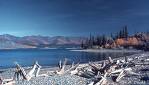
We stopped and took pictures of Muncho Lake, 444 miles from Dawson Creek known for its deep green and blue water. No ice on this deep lake reaching depths of over 700 feet and stretching over 7 miles in length.
We arrived at Liard River RV Park on the Laird River after driving 496 miles stopping several times and enjoyed every mile. If you enjoy nature’s beauty then get off the sofa. Remember one thing when traveling with an RV, take along a tool box because you will need it about every thousand miles or sooner.
We headed out before sunrise at 0430. It was light out though. I heard a few moans and groans, but I assured them the bear will be waiting for us. We hadn’t traveled 25 miles from our camp grounds when we spotted the largest wolf I’ve ever seen and possibly anyone had ever seen .This animal was the size of a small brown bear. Its head was enormous. I stopped the RV and opened the door slowly so not too spook the large black wolf. He or she stood there not 100 feet from us letting us know that we were in his or her territory and he or she wasn’t running. He or she looked hungry and no I didn’t throw any stones in his or her direction. I snapped a picture and climbed into the RV. The wolf walked away with his or her eyes on us. I couldn’t make out the sex of the wolf at 100 feet. Too much hair left from his winter coat.
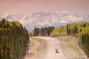
The road so far has been great. It is asphalt with a few frost heaves. The traffic is sparse, Canada is on a holiday and the truck traffic is non existent. Great for sightseeing, you can take up the whole road or stop anywhere to shoot a picture. A great time to travel this road providing you get off the sofa.
Where the buffalo roam is along the Alaska Highway. We saw approximately 30 wild buffalo in a herd along the road grazing and a few in the middle of the road. A few miles further we saw 2 large male buffalo fighting along with several cows watching the fight. The dust was flying their tails dancing and their heads crashing against one another. Somebody was going to win, but we opted to drive on.
We are in Yukon Territory and closing in on Watson Lake or the gateway to the Yukon. They receive over 90 inches of snowfall every winter. Record low was minus 74 degrees Fahrenheit. That is below zero in case you want drive up the highway in the winter.
We filled our gas tank. Gas and diesel stops are plentiful so far. Always fill up when you have around a half a tank just in case the next station is closed or out of gas.
Fireweed is the territorial flower of the Yukon. We drove along the Rancheria River for several miles. The waysides or rest stops with porta toilets are scattered every 50 miles or so. The toilet paper rolls are padlocked to the wall and there are no toilet seats. I asked a maintenance guy who was painting one of the toilets about the toilet seats. He said people steal them so they quit installing them. Even in the Yukon they have thieves.
More black bears, moose, antelope, mountain sheep, coyotes, and bison were seen along with a couple of white eagles. We saw several wild horses galloping several hundred feet away.
We pulled into Hi Country RV Park in Whitehorse, Yukon Territory, after driving 466 miles. We have over 3000 miles on the RV since we picked it up in Indiana. Oil change is due on the motor home and $100.00 later we got her done.
White Horse sits on the Yukon River and has a population of 23,511. We drove into town and had an excellent meal at Klondike Rib and Salmon, the oldest operating building in Whitehorse. We had baked salmon, fried potatoes and mixed green vegetables. That wasn’t enough so we had warm apple crisp piled high with homemade vanilla ice cream. We shared the desert as it was big enough for three anyway. The service was excellent. Many stories and laughs were shared by the three seniors.
We left a very nice RV park in Whitehorse, Yukon Territory at 0545 for the one of the most pristine states, Alaska. The frost heaves in the road made driving like running a dune buggy over sand dunes. If you haven’t done that maybe you should think about it. The heaves were every quarter mile, now they are every 500 feet. We have the whole road to use so I hit the frost heaves on an angle trying to ease the ride for Jim who was sitting on a thin padded seat. His low back began to cry for more cushions. He used his pillow.
Beaver Creek a small town, population 112 is where you will find Buckshot Betty’s. They make all their own pastries, breads, pies, cookies and anything else sweet. You can pay in gold nugget, cash or they have an ATM close by, a good place to stretch your legs guys, and let the ladies browse around. We didn’t browse much. We arrived at the Alaska border and had a lady border patrol officer to deal with. Her once a week smile faded the moment she laid eyes on me behind the wheel. She asked us for our passports, and did we have more than $10,000 in cash. Mike spoke up in his eastern accent, "No we are all divorced." He laughed, but she never even blinked just stared at Mike. I asked her where she lived. One word answer, TOK, Alaska.
It is 1221.8 miles from Dawson Creek to the border. We made it!
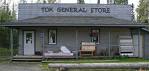
Tok, Alaska, population 1435 is the first town you come to in Alaska. Now I see why the lady border patrol officer didn’t smile. The name Tok was named after a husky pup who became the mascot of the all Black Army Corp of Engineers. Tok is known as the dog sled capital of Alaska. We took highway 1 or Glen Highway or Tok Cut Off out of Tok toward Gakoma where we picked up the Richardson Highway. The Wrangell-St.Elias National Park and Reserve is where the Mount Sanford peaks out at 16,257. Awesome! The road is asphalt, but the frost heaves are now every twenty feet. Jim is crying. Our stomachs are in our throats.
The gas gauge is riding on empty. Yes we failed to get gas in Tok because they wanted too much per gallon. My suggestion is to get enough to carry you to the next station. I looked at the map and figured we could make it to Glennallen. That turned out to be a bad call. The first three stations we passed were boarded up and then we came upon a small berg not even on the map. The station had one very old rusted pump. We were fifty miles from Glennallen and nowhere to camp.
When I stepped out of the RV and walked to the front of the shack that represented the gas station I was approached by a large lady dressed in bib overhauls. Her hair looked like it had been through a tornado and someone or something took most of her teeth from her mouth. Her hands were twice my hand size and I have a large hand. The enormous dog that sprawled across the wooden plank floor raised one eye. This dog was about as big as the wolf we saw 1100 miles down the road.
"Do you have any gas for our RV? I asked keeping one eye on the dog.
"Yes sir! And I have the cheapest gas in these parts." She gave me a big grin.
I pumped over $89.00 into the tank and paid the lady and drove off. I figured it would be cheaper in Valdez. We looked for an RV park, but there wasn’t anything until we arrived in Glennallen. The sign pointed to the right and another sign told us it was 25 miles to the park after we turned. I did a U turn and headed toward Valdez where we wanted to go. It was only another 115 miles to Valdez. We were all tired, but the scenery kept us awake.
Let me tell you that 115 miles was the most picturesque ride I ever been on. The snow capped mountains, the rivers, lakes, waterfalls every few miles and the road had more curves than my favorite movie star. The Worthington Glacier is spectacular. The clouds laid in the mountains making it look like fog and with the sun trying to penetrate through the clouds gave you chills just looking at the spectacle before us.
We all were in awe and driving very slowly due to the frost heaves which are now every ten feet. We picked up a gigantic bald eagle that flew in front of the RV through this magnificent canyon. The eagle was not more than 10 feet in front of us and about 15 feet off the ground. The eagle’s wing span was almost as wide as the RV, an awesome sight. The eagle flew with us for several miles.
We arrived in Valdez, Exxon’s big debacle (oil spill) several years ago that this community is still dealing with. The view from our camp grounds (Bear Paw RV) was absolutely magnificent. They call Valdez Little Switzerland. We traveled 645 miles and over 500 miles was very scenic.
Valdez has only 4454 people and last year they had over 24 feet of snow. The Alaska pipeline which is over 800 miles long ends at Valdez.
In 1964 Valdez sat 4 miles east of its present location. On Good Friday of that year an earthquake, the most destructive earthquake ever to hit south central Alaska virtually destroyed Valdez. The quake measured 9.2 on the Richter scale. The quake hit out in the water and engulfed the wharf taking 33 people with it.
The present city limits has an area of 274 square miles that includes all surrounding mountains to the timberline. Valdez beautiful setting comes with the Chugach Mountains rising above the city and the small boat harbor in front. If you ever go to Alaska be sure to visit this magnificent city for its beauty alone.
We spent two days in Valdez exploring and giving Jim’s rump a rest. We departed at 0630 up the Richardson Highway or highway 4 toward Glennallen where we picked up highway 1 or Glen Highway heading toward Anchorage. Highway 1 was much easier on Jim. We had the opportunity to see a close up view of the Alaska Pipeline just before we reached Glennallen. The scenery with the majestic mountains and glaciers and the warm bright sun made this trip feel like you were in an IMAX Theater. We drove through Palmer, Alaska elevation of 232 feet and population of 5474. The New Deal under FDR’s administration planned an agriculture potential in the Matanuska Valley outside of Palmer for those who had problems with the great depression and the dust bowls of the 30’s. In 1935 they took 203 families from Minnesota, Wisconsin and Michigan or the hardy Scandinavian groups to Palmer. Although the failure rate was high there are still descendants living in the area. The growing season is 80 to 110 days per year with total sunshine for long hours per day. The vegetables from this area feed Anchorage and Fairbanks and most other areas of Alaska.
We bypassed Anchorage and headed toward Wasilla, Alaska. Their growth exceeds 40% since 2000. Most of the people are retired from the bottom 48 believe or not. We loaded up with food and supplies along with liquor, wine and etc in Wasilla. The traffic was like rush hour somewhere in the lower forty-eight. We saw more cars today in two hours then we have seen in the past two weeks combined. Next: We will see you in Denali National Park.
Denali National Park and Preserve was established 1917 as Mount McKinley National Park. It was renamed in 1980 as Denali National Park and it lays 250 miles south of the Artic Circle. The park is open year round. The park encompasses over 6 million acres including MT. McKinley. We camped at Riley Creek Campground a wooded and clean RV park. The facilities were less than 100 feet from our RV. The showers however drilled holes into your body. They must have been at least 1000 pci shower heads. Not a fun experience if you know what I mean.
We took a bus tour of the park the only way you can see the park as they have restrictions on using private vehicles. Our bus driver and tour director told several stories about his explorations of Alaska. I had my doubts on the stories of him climbing Mount McKinley. I never climbed a mountain as high as Mt. McKinley, but have climbed several 14,000 foot mountains in Colorado. His answers to my questions were not from a man who climbed Mt. McKinley or any other mountain. I wonder sometimes why people have to tell stories that are not true.
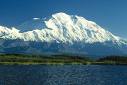
The mountain peaks out at 20,320 feet the tallest peak in North America. An awesome sight if you ever get an opportunity to see it. Today we saw it, but with several clouds floating around it making visibility poor. The top is blocked by clouds most of the time. I saw it once before and that was from an airplane taking off from Anchorage with the sun shinning brightly on its snow capped top.
The bus tour was not as great as expected. The bus was older than me and made enough noise to scare a scarecrow away. We saw moose, deer, elk, wolves, Big Horn Sheep, and some people saw a grizzly bear. I didn’t, but I’m getting old. Not one of my buddies saw the bear either. If you haven’t been to Denali National Park, by all means see it before you fall off the couch. I have seen it twice now and if ever I get back here I will go again. Maybe on a different bus once our government donates some National Parks money.
We spent three nights at the Riley Creek RV Park. The first time the weather has been warm enough to sit outside and enjoy a nice glass of wine. It turns very cool at night however, but great for sleeping.
The ride from Denali National Park to Anchorage was just a shade above boring. The195 miles from Denali to Wasilla we had already traveled only in the other direction so Mike kept us from falling a sleep with several new tales and laughter always included. If you decide to get off the sofa and travel and start to nod off start laughing it will increase the blood flow.
Thanks to Mike who loves museums no matter where they are or what they have for viewing saw the sign along the highway. I slowed and barley made the turn down a narrow dirt road to a large display of all kinds of transportation methods from farm tractors, cars, trucks, trains, planes, helicopters, etc. We stretched our legs at Alaska Transportation Museum near Wasilla. The weather was cold with rain, wind and neither of us wearing enough clothes. Most of the equipment was either outside or housed in an open shed.
We buzzed right through Anchorage as this will be our last stop of the trip. We are heading south on Seward Highway where we stopped at Alaska Wildlife Conservation Center. The weather was still wet and cold but we managed to get pictures of four big brown bears frolicking in a pool of water. Several wolves, elk, deer, buffalo, and other animals were kind enough too stand still and pose for pictures.
Turnagain Arm is known for one of the worlds remarkably high tides of more than 33 feet. Several small craft and there occupants have been swept away and never found again from these high tides or bore tides.
We stopped at Portage Glacier one of the worlds most spectacular sights but were unable to see anything due to the fog. We watched a wide screen movie of it instead in the warm theater.
We moved on to Whittier a small village (290 people) which sits on the head of Passage Canal of Prince William Sound. In order to get to Whittier you must pay a toll for a 2.5 mile one lane tunnel that was just completed in 2000, prior to that you had to use the train or boat to see Whittier. The tunnel is called the Anton Anderson Tunnel where trains and vehicles use the same one lane tunnel. That can be exciting if someone doesn’t wait. There are staging areas at each end to keep that from happening.
Seward, Alaska is a very popular stopping area for cruise ships. Seward has a population of 2606. There is 470 mile railroad connecting Seward to Fairbanks. Cruise passengers take this train for there inland travel. Seward sits on Resurrection Bay an ice free bay 365 days per year.
We camped at a retired Air Force RV camp ground even though we were former Air Force Airmen that never made a career of the military. They let us stay for free because our man Mike convinced them we were all serving for the same reason and the place was virtually empty. They had a recreation hall with pool tables, table tennis, and wide screen TV. I watched an old Glen Ford western with some old retired Army sergeant. A nice relaxing evening away from my traveling buddies.
We took a day cruise on a large catamaran that held a couple hundred people. The weather was not good for taking pictures of sea otters, sea lions, whales, eagles, and sea coast of Resurrection Bay.
We ate dinner at The Salmon Bake restaurant outside of Seward. The restaurant had old wooden floors with a pot belly stove that we huddled around while we stuffed ourselves with baked salmon and all the trimmings. The food was excellent and highly recommended by the three of us.
© Sam Black March 2009
sblk05 at hotmail.comMore Travel
Planning the Trip
Sam Black in Alaska
I believe in having goals.
North to Alaska Pt 2
Sam Black
Petoskey sits on Lake Michigan I suggest you visit it someday.
North To Alaska - Part 3 & 4
Sam Black
We headed out at 0600 on Highway 2 westbound. Our goal is to drive as far as we can. The state of North Dakota is rather boring until you get to Devils Lake
Home© Hackwriters 1999-2022
all rights reserved - all comments are the writers' own responsibility - no liability accepted by hackwriters.com or affiliates.